You are here: Home > Network List > NN - Western Great Basin/Eastern Sierra Nevada Stations List
> Station VCN Virginia City, Nevada gps > Earthquake Result Viewer
VCN Virginia City, Nevada gps - Earthquake Result Viewer
| Earthquake location: |
Kermadec Islands Region |
| Earthquake latitude/longitude: |
-30.5/-176.5 |
| Earthquake time(UTC): |
2014/07/03 (184) 19:50:05 GMT |
| Earthquake Depth: |
20 km |
| Earthquake Magnitude: |
6.3 MWB, 6.6 MI |
| Earthquake Catalog/Contributor: |
NEIC PDE/NEIC COMCAT |
|
| Network: |
NN Western Great Basin/Eastern Sierra Nevada |
| Station: |
VCN Virginia City, Nevada gps |
| Lat/Lon: |
39.30 N/119.65 W |
| Elevation: |
1928 m |
|
| Distance: |
87.3 deg |
| Az: |
40.585 deg |
| Baz: |
226.336 deg |
| Ray Param: |
0.043400276 |
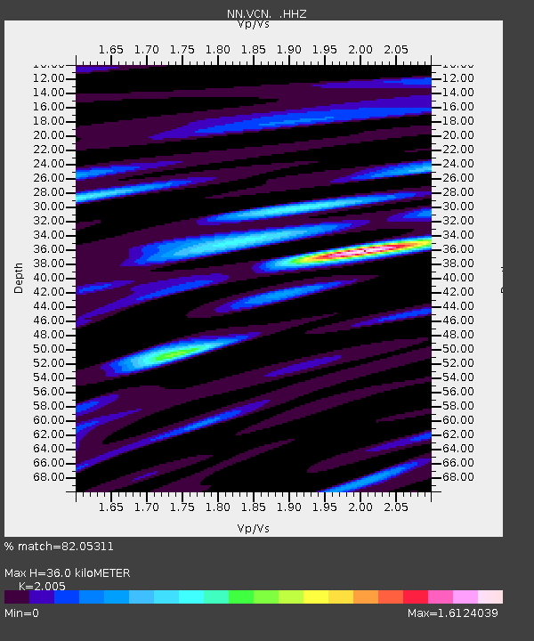
| Estimated Moho Depth: |
36.0 km |
| Estimated Crust Vp/Vs: |
2.01 |
| Assumed Crust Vp: |
6.279 km/s |
| Estimated Crust Vs: |
3.131 km/s |
| Estimated Crust Poisson's Ratio: |
0.33 |
|
| Radial Match: |
82.05311 % |
| Radial Bump: |
400 |
| Transverse Match: |
88.6236 % |
| Transverse Bump: |
400 |
| SOD ConfigId: |
751272 |
| Insert Time: |
2014-07-17 20:37:42.002 +0000 |
| GWidth: |
2.5 |
| Max Bumps: |
400 |
| Tol: |
0.001 |
|

Signal To Noise
| Channel | StoN | STA | LTA |
| NN:VCN: :HHZ:20140703T20:02:18.815024Z | 22.035551 | 2.679528E-6 | 1.2160022E-7 |
| NN:VCN: :HHN:20140703T20:02:18.815024Z | 7.7738795 | 1.1760435E-6 | 1.5128141E-7 |
| NN:VCN: :HHE:20140703T20:02:18.815024Z | 2.4239357 | 4.1115945E-7 | 1.6962474E-7 |
| Arrivals |
| Ps | 5.9 SECOND |
| PpPs | 17 SECOND |
| PsPs/PpSs | 23 SECOND |


