You are here: Home > Network List > TA - USArray Transportable Network (new EarthScope stations) Stations List
> Station A04D Lummi Island, WA, USA > Earthquake Result Viewer
A04D Lummi Island, WA, USA - Earthquake Result Viewer
*The percent match for this event was below the threshold and hence no stack was calculated.
| Earthquake location: |
Kermadec Islands Region |
| Earthquake latitude/longitude: |
-30.5/-176.5 |
| Earthquake time(UTC): |
2014/07/03 (184) 19:50:05 GMT |
| Earthquake Depth: |
20 km |
| Earthquake Magnitude: |
6.3 MWB, 6.6 MI |
| Earthquake Catalog/Contributor: |
NEIC PDE/NEIC COMCAT |
|
| Network: |
TA USArray Transportable Network (new EarthScope stations) |
| Station: |
A04D Lummi Island, WA, USA |
| Lat/Lon: |
48.72 N/122.71 W |
| Elevation: |
13 m |
|
| Distance: |
92.4 deg |
| Az: |
32.343 deg |
| Baz: |
224.19 deg |
| Ray Param: |
$rayparam |
*The percent match for this event was below the threshold and hence was not used in the summary stack. |
|
| Radial Match: |
75.23392 % |
| Radial Bump: |
400 |
| Transverse Match: |
75.24082 % |
| Transverse Bump: |
400 |
| SOD ConfigId: |
751272 |
| Insert Time: |
2014-07-17 20:41:28.705 +0000 |
| GWidth: |
2.5 |
| Max Bumps: |
400 |
| Tol: |
0.001 |
|
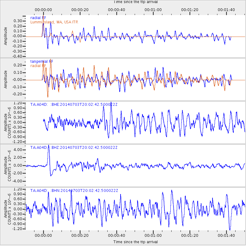
Signal To Noise
| Channel | StoN | STA | LTA |
| TA:A04D: :BHZ:20140703T20:02:42.500022Z | 17.101765 | 2.0552195E-6 | 1.2017588E-7 |
| TA:A04D: :BHN:20140703T20:02:42.500022Z | 1.2288214 | 3.6142873E-7 | 2.9412632E-7 |
| TA:A04D: :BHE:20140703T20:02:42.500022Z | 1.9511957 | 3.6953224E-7 | 1.8938759E-7 |
| Arrivals |
| Ps | |
| PpPs | |
| PsPs/PpSs | |


