You are here: Home > Network List > TA - USArray Transportable Network (new EarthScope stations) Stations List
> Station I03D Drain, OR, USA > Earthquake Result Viewer
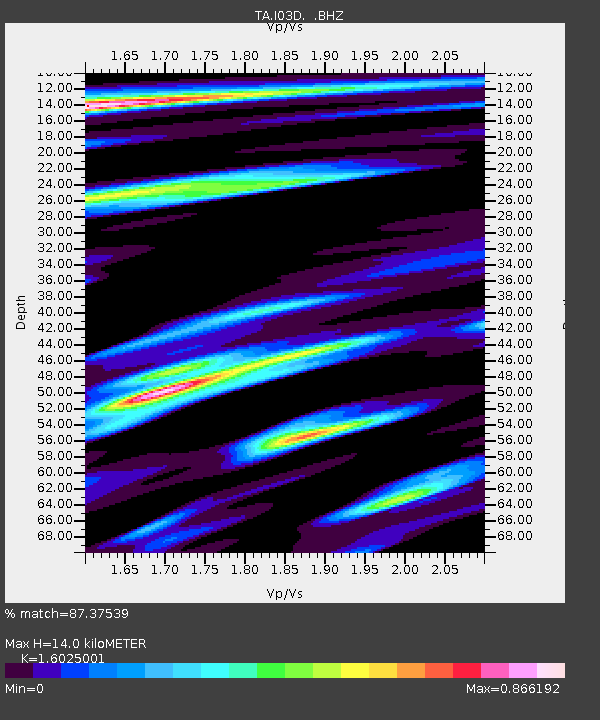
I03D Drain, OR, USA - Earthquake Result Viewer
| Earthquake location: |
Kermadec Islands Region |
| Earthquake latitude/longitude: |
-30.5/-176.5 |
| Earthquake time(UTC): |
2014/07/03 (184) 19:50:05 GMT |
| Earthquake Depth: |
20 km |
| Earthquake Magnitude: |
6.3 MWB, 6.6 MI |
| Earthquake Catalog/Contributor: |
NEIC PDE/NEIC COMCAT |
|
| Network: |
TA USArray Transportable Network (new EarthScope stations) |
| Station: |
I03D Drain, OR, USA |
| Lat/Lon: |
43.70 N/123.35 W |
| Elevation: |
140 m |
|
| Distance: |
88.4 deg |
| Az: |
35.508 deg |
| Baz: |
223.704 deg |
| Ray Param: |
0.04256211 |
| Estimated Moho Depth: |
14.0 km |
| Estimated Crust Vp/Vs: |
1.60 |
| Assumed Crust Vp: |
6.522 km/s |
| Estimated Crust Vs: |
4.07 km/s |
| Estimated Crust Poisson's Ratio: |
0.18 |
|
| Radial Match: |
87.37539 % |
| Radial Bump: |
352 |
| Transverse Match: |
75.80919 % |
| Transverse Bump: |
389 |
| SOD ConfigId: |
751272 |
| Insert Time: |
2014-07-17 20:42:55.222 +0000 |
| GWidth: |
2.5 |
| Max Bumps: |
400 |
| Tol: |
0.001 |
|

Signal To Noise
| Channel | StoN | STA | LTA |
| TA:I03D: :BHZ:20140703T20:02:24.274985Z | 16.588583 | 3.3284105E-6 | 2.0064465E-7 |
| TA:I03D: :BHN:20140703T20:02:24.274985Z | 3.615713 | 7.5214814E-7 | 2.0802207E-7 |
| TA:I03D: :BHE:20140703T20:02:24.274985Z | 3.8149352 | 6.629722E-7 | 1.7378335E-7 |
| Arrivals |
| Ps | 1.3 SECOND |
| PpPs | 5.5 SECOND |
| PsPs/PpSs | 6.8 SECOND |


