You are here: Home > Network List > II - Global Seismograph Network (GSN - IRIS/IDA) Stations List
> Station ESK Eskdalemuir, Scotland, UK > Earthquake Result Viewer
ESK Eskdalemuir, Scotland, UK - Earthquake Result Viewer
| Earthquake location: |
Lake Tanganyika Region |
| Earthquake latitude/longitude: |
-6.2/29.8 |
| Earthquake time(UTC): |
2005/12/05 (339) 12:19:56 GMT |
| Earthquake Depth: |
22 km |
| Earthquake Magnitude: |
6.4 MB, 7.2 MS, 6.8 MW, 6.7 MW |
| Earthquake Catalog/Contributor: |
WHDF/NEIC |
|
| Network: |
II Global Seismograph Network (GSN - IRIS/IDA) |
| Station: |
ESK Eskdalemuir, Scotland, UK |
| Lat/Lon: |
55.32 N/3.20 W |
| Elevation: |
242 m |
|
| Distance: |
67.2 deg |
| Az: |
340.238 deg |
| Baz: |
143.98 deg |
| Ray Param: |
0.05710818 |
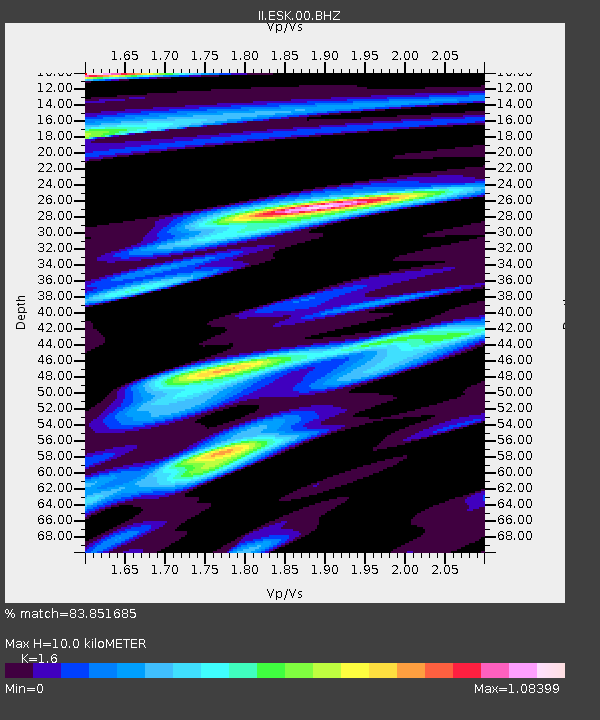
| Estimated Moho Depth: |
10.0 km |
| Estimated Crust Vp/Vs: |
1.60 |
| Assumed Crust Vp: |
6.276 km/s |
| Estimated Crust Vs: |
3.922 km/s |
| Estimated Crust Poisson's Ratio: |
0.18 |
|
| Radial Match: |
83.851685 % |
| Radial Bump: |
400 |
| Transverse Match: |
58.54643 % |
| Transverse Bump: |
400 |
| SOD ConfigId: |
2422 |
| Insert Time: |
2010-03-01 23:49:26.967 +0000 |
| GWidth: |
2.5 |
| Max Bumps: |
400 |
| Tol: |
0.001 |
|
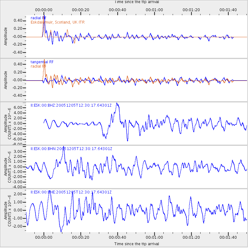
Signal To Noise
| Channel | StoN | STA | LTA |
| II:ESK:00:BHN:20051205T12:30:17.64301Z | 3.1632347 | 1.4033536E-6 | 4.436451E-7 |
| II:ESK:00:BHE:20051205T12:30:17.64301Z | 1.684231 | 1.3247534E-6 | 7.865628E-7 |
| II:ESK:00:BHZ:20051205T12:30:17.64301Z | 4.2655277 | 3.1676311E-6 | 7.426118E-7 |
| Arrivals |
| Ps | 1.0 SECOND |
| PpPs | 4.0 SECOND |
| PsPs/PpSs | 5.0 SECOND |


