You are here: Home > Network List > TA - USArray Transportable Network (new EarthScope stations) Stations List
> Station O03E Paynes Creek, CA, USA > Earthquake Result Viewer
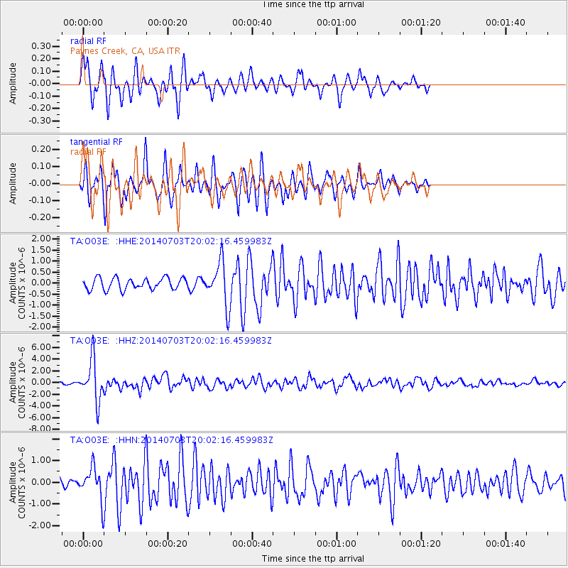
O03E Paynes Creek, CA, USA - Earthquake Result Viewer
*The percent match for this event was below the threshold and hence no stack was calculated.
| Earthquake location: |
Kermadec Islands Region |
| Earthquake latitude/longitude: |
-30.5/-176.5 |
| Earthquake time(UTC): |
2014/07/03 (184) 19:50:05 GMT |
| Earthquake Depth: |
20 km |
| Earthquake Magnitude: |
6.3 MWB, 6.6 MI |
| Earthquake Catalog/Contributor: |
NEIC PDE/NEIC COMCAT |
|
| Network: |
TA USArray Transportable Network (new EarthScope stations) |
| Station: |
O03E Paynes Creek, CA, USA |
| Lat/Lon: |
40.29 N/121.80 W |
| Elevation: |
967 m |
|
| Distance: |
86.8 deg |
| Az: |
38.71 deg |
| Baz: |
224.868 deg |
| Ray Param: |
$rayparam |
*The percent match for this event was below the threshold and hence was not used in the summary stack. |
|
| Radial Match: |
80.64379 % |
| Radial Bump: |
295 |
| Transverse Match: |
83.85534 % |
| Transverse Bump: |
345 |
| SOD ConfigId: |
751272 |
| Insert Time: |
2014-07-17 20:43:59.988 +0000 |
| GWidth: |
2.5 |
| Max Bumps: |
400 |
| Tol: |
0.001 |
|
Signal To Noise
| Channel | StoN | STA | LTA |
| TA:O03E: :HHZ:20140703T20:02:16.459983Z | 31.051105 | 3.5916232E-6 | 1.1566813E-7 |
| TA:O03E: :HHN:20140703T20:02:16.459983Z | 3.4570694 | 7.37348E-7 | 2.1328701E-7 |
| TA:O03E: :HHE:20140703T20:02:16.459983Z | 3.9523592 | 1.0321052E-6 | 2.6113645E-7 |
| Arrivals |
| Ps | |
| PpPs | |
| PsPs/PpSs | |


