You are here: Home > Network List > UW - Pacific Northwest Regional Seismic Network Stations List
> Station LCCR Mulino, OR, USA > Earthquake Result Viewer
LCCR Mulino, OR, USA - Earthquake Result Viewer
| Earthquake location: |
Kermadec Islands Region |
| Earthquake latitude/longitude: |
-30.5/-176.5 |
| Earthquake time(UTC): |
2014/07/03 (184) 19:50:05 GMT |
| Earthquake Depth: |
20 km |
| Earthquake Magnitude: |
6.3 MWB, 6.6 MI |
| Earthquake Catalog/Contributor: |
NEIC PDE/NEIC COMCAT |
|
| Network: |
UW Pacific Northwest Regional Seismic Network |
| Station: |
LCCR Mulino, OR, USA |
| Lat/Lon: |
45.21 N/122.48 W |
| Elevation: |
273 m |
|
| Distance: |
90.0 deg |
| Az: |
34.909 deg |
| Baz: |
224.304 deg |
| Ray Param: |
0.041705433 |
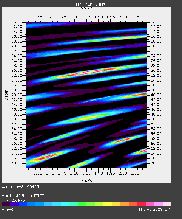
| Estimated Moho Depth: |
62.5 km |
| Estimated Crust Vp/Vs: |
2.10 |
| Assumed Crust Vp: |
6.566 km/s |
| Estimated Crust Vs: |
3.13 km/s |
| Estimated Crust Poisson's Ratio: |
0.35 |
|
| Radial Match: |
84.05425 % |
| Radial Bump: |
384 |
| Transverse Match: |
81.812515 % |
| Transverse Bump: |
400 |
| SOD ConfigId: |
751272 |
| Insert Time: |
2014-07-17 20:50:01.429 +0000 |
| GWidth: |
2.5 |
| Max Bumps: |
400 |
| Tol: |
0.001 |
|

Signal To Noise
| Channel | StoN | STA | LTA |
| UW:LCCR: :HHZ:20140703T20:02:31.357993Z | 24.03382 | 3.7265456E-6 | 1.5505425E-7 |
| UW:LCCR: :HHN:20140703T20:02:31.357993Z | 6.9887285 | 1.3366961E-6 | 1.9126456E-7 |
| UW:LCCR: :HHE:20140703T20:02:31.357993Z | 2.1384919 | 7.1896756E-7 | 3.362031E-7 |
| Arrivals |
| Ps | 11 SECOND |
| PpPs | 29 SECOND |
| PsPs/PpSs | 40 SECOND |


