You are here: Home > Network List > UW - Pacific Northwest Regional Seismic Network Stations List
> Station UMAT Pilot Rock, OR, USA > Earthquake Result Viewer
UMAT Pilot Rock, OR, USA - Earthquake Result Viewer
| Earthquake location: |
Kermadec Islands Region |
| Earthquake latitude/longitude: |
-30.5/-176.5 |
| Earthquake time(UTC): |
2014/07/03 (184) 19:50:05 GMT |
| Earthquake Depth: |
20 km |
| Earthquake Magnitude: |
6.3 MWB, 6.6 MI |
| Earthquake Catalog/Contributor: |
NEIC PDE/NEIC COMCAT |
|
| Network: |
UW Pacific Northwest Regional Seismic Network |
| Station: |
UMAT Pilot Rock, OR, USA |
| Lat/Lon: |
45.29 N/118.96 W |
| Elevation: |
1318 m |
|
| Distance: |
91.8 deg |
| Az: |
36.59 deg |
| Baz: |
226.769 deg |
| Ray Param: |
0.041551594 |
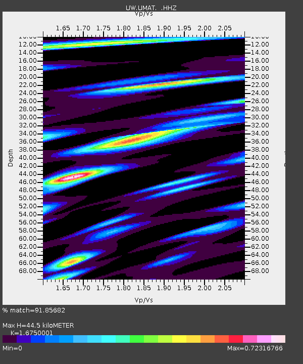
| Estimated Moho Depth: |
44.5 km |
| Estimated Crust Vp/Vs: |
1.68 |
| Assumed Crust Vp: |
6.571 km/s |
| Estimated Crust Vs: |
3.923 km/s |
| Estimated Crust Poisson's Ratio: |
0.22 |
|
| Radial Match: |
91.85682 % |
| Radial Bump: |
308 |
| Transverse Match: |
80.6429 % |
| Transverse Bump: |
350 |
| SOD ConfigId: |
751272 |
| Insert Time: |
2014-07-17 20:51:02.226 +0000 |
| GWidth: |
2.5 |
| Max Bumps: |
400 |
| Tol: |
0.001 |
|
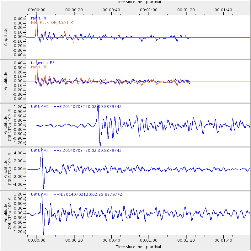
Signal To Noise
| Channel | StoN | STA | LTA |
| UW:UMAT: :HHZ:20140703T20:02:39.837974Z | 26.89508 | 2.4377534E-6 | 9.063938E-8 |
| UW:UMAT: :HHN:20140703T20:02:39.837974Z | 13.871515 | 5.9349577E-7 | 4.2785214E-8 |
| UW:UMAT: :HHE:20140703T20:02:39.837974Z | 12.465365 | 6.877105E-7 | 5.51697E-8 |
| Arrivals |
| Ps | 4.7 SECOND |
| PpPs | 18 SECOND |
| PsPs/PpSs | 22 SECOND |


