You are here: Home > Network List > WY - Yellowstone Wyoming Seismic Network Stations List
> Station YHH Holmes Hill, YNP, WY, USA > Earthquake Result Viewer
YHH Holmes Hill, YNP, WY, USA - Earthquake Result Viewer
| Earthquake location: |
Kermadec Islands Region |
| Earthquake latitude/longitude: |
-30.5/-176.5 |
| Earthquake time(UTC): |
2014/07/03 (184) 19:50:05 GMT |
| Earthquake Depth: |
20 km |
| Earthquake Magnitude: |
6.3 MWB, 6.6 MI |
| Earthquake Catalog/Contributor: |
NEIC PDE/NEIC COMCAT |
|
| Network: |
WY Yellowstone Wyoming Seismic Network |
| Station: |
YHH Holmes Hill, YNP, WY, USA |
| Lat/Lon: |
44.79 N/110.85 W |
| Elevation: |
2717 m |
|
| Distance: |
95.8 deg |
| Az: |
40.712 deg |
| Baz: |
232.217 deg |
| Ray Param: |
0.040668417 |
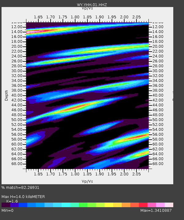
| Estimated Moho Depth: |
14.0 km |
| Estimated Crust Vp/Vs: |
1.60 |
| Assumed Crust Vp: |
6.35 km/s |
| Estimated Crust Vs: |
3.969 km/s |
| Estimated Crust Poisson's Ratio: |
0.18 |
|
| Radial Match: |
82.26931 % |
| Radial Bump: |
310 |
| Transverse Match: |
80.555145 % |
| Transverse Bump: |
352 |
| SOD ConfigId: |
751272 |
| Insert Time: |
2014-07-17 20:51:21.527 +0000 |
| GWidth: |
2.5 |
| Max Bumps: |
400 |
| Tol: |
0.001 |
|
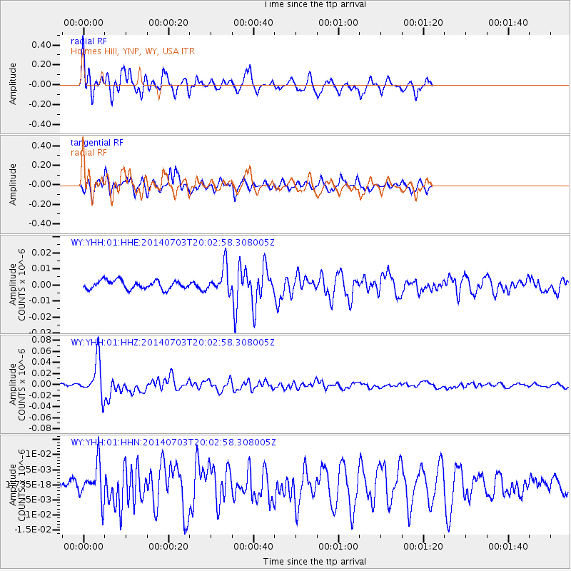
Signal To Noise
| Channel | StoN | STA | LTA |
| WY:YHH:01:HHZ:20140703T20:02:58.308005Z | 11.980006 | 3.3912865E-8 | 2.8307885E-9 |
| WY:YHH:01:HHN:20140703T20:02:58.308005Z | 2.5913057 | 6.196673E-9 | 2.3913322E-9 |
| WY:YHH:01:HHE:20140703T20:02:58.308005Z | 3.114084 | 8.23103E-9 | 2.6431626E-9 |
| Arrivals |
| Ps | 1.4 SECOND |
| PpPs | 5.6 SECOND |
| PsPs/PpSs | 7.0 SECOND |


