You are here: Home > Network List > YN10 - San Jacinto Fault Zone Stations List
> Station JFN4 JFN4 > Earthquake Result Viewer
JFN4 JFN4 - Earthquake Result Viewer
| Earthquake location: |
Kermadec Islands Region |
| Earthquake latitude/longitude: |
-30.5/-176.5 |
| Earthquake time(UTC): |
2014/07/03 (184) 19:50:05 GMT |
| Earthquake Depth: |
20 km |
| Earthquake Magnitude: |
6.3 MWB, 6.6 MI |
| Earthquake Catalog/Contributor: |
NEIC PDE/NEIC COMCAT |
|
| Network: |
YN San Jacinto Fault Zone |
| Station: |
JFN4 JFN4 |
| Lat/Lon: |
33.42 N/116.40 W |
| Elevation: |
646 m |
|
| Distance: |
85.3 deg |
| Az: |
46.689 deg |
| Baz: |
228.652 deg |
| Ray Param: |
0.04486018 |
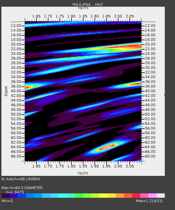
| Estimated Moho Depth: |
64.0 km |
| Estimated Crust Vp/Vs: |
1.95 |
| Assumed Crust Vp: |
6.264 km/s |
| Estimated Crust Vs: |
3.216 km/s |
| Estimated Crust Poisson's Ratio: |
0.32 |
|
| Radial Match: |
89.194954 % |
| Radial Bump: |
400 |
| Transverse Match: |
81.52169 % |
| Transverse Bump: |
400 |
| SOD ConfigId: |
751272 |
| Insert Time: |
2014-07-17 20:52:39.893 +0000 |
| GWidth: |
2.5 |
| Max Bumps: |
400 |
| Tol: |
0.001 |
|

Signal To Noise
| Channel | StoN | STA | LTA |
| YN:JFN4: :HHZ:20140703T20:02:08.883994Z | 28.207838 | 3.794798E-6 | 1.3452991E-7 |
| YN:JFN4: :HHN:20140703T20:02:08.883994Z | 5.4567237 | 8.291813E-7 | 1.5195589E-7 |
| YN:JFN4: :HHE:20140703T20:02:08.883994Z | 4.7724867 | 1.11097E-6 | 2.3278639E-7 |
| Arrivals |
| Ps | 9.9 SECOND |
| PpPs | 29 SECOND |
| PsPs/PpSs | 39 SECOND |


