You are here: Home > Network List > AK - Alaska Regional Network Stations List
> Station BRLK Bradley Lake > Earthquake Result Viewer
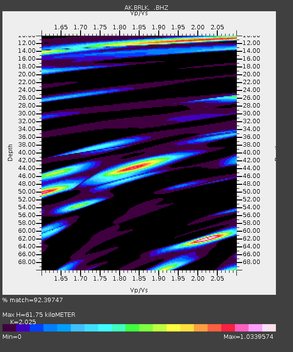
BRLK Bradley Lake - Earthquake Result Viewer
| Earthquake location: |
New Britain Region, P.N.G. |
| Earthquake latitude/longitude: |
-6.2/152.8 |
| Earthquake time(UTC): |
2014/07/04 (185) 15:00:26 GMT |
| Earthquake Depth: |
10 km |
| Earthquake Magnitude: |
6.6 MWP, 6.7 MI |
| Earthquake Catalog/Contributor: |
NEIC PDE/NEIC COMCAT |
|
| Network: |
AK Alaska Regional Network |
| Station: |
BRLK Bradley Lake |
| Lat/Lon: |
59.75 N/150.91 W |
| Elevation: |
409 m |
|
| Distance: |
79.2 deg |
| Az: |
25.38 deg |
| Baz: |
237.322 deg |
| Ray Param: |
0.04910443 |
| Estimated Moho Depth: |
61.75 km |
| Estimated Crust Vp/Vs: |
2.03 |
| Assumed Crust Vp: |
6.24 km/s |
| Estimated Crust Vs: |
3.081 km/s |
| Estimated Crust Poisson's Ratio: |
0.34 |
|
| Radial Match: |
92.39747 % |
| Radial Bump: |
400 |
| Transverse Match: |
84.22981 % |
| Transverse Bump: |
400 |
| SOD ConfigId: |
751272 |
| Insert Time: |
2014-07-18 15:07:26.315 +0000 |
| GWidth: |
2.5 |
| Max Bumps: |
400 |
| Tol: |
0.001 |
|

Signal To Noise
| Channel | StoN | STA | LTA |
| AK:BRLK: :BHZ:20140704T15:12:00.268013Z | 58.792866 | 3.3732067E-6 | 5.737442E-8 |
| AK:BRLK: :BHN:20140704T15:12:00.268013Z | 7.900125 | 5.328655E-7 | 6.745026E-8 |
| AK:BRLK: :BHE:20140704T15:12:00.268013Z | 10.655566 | 1.0261984E-6 | 9.630633E-8 |
| Arrivals |
| Ps | 10 SECOND |
| PpPs | 29 SECOND |
| PsPs/PpSs | 40 SECOND |


