You are here: Home > Network List > 1U - Mt. Paektu Seismic Network Stations List
> Station JGPD Jang Gun Peak > Earthquake Result Viewer
JGPD Jang Gun Peak - Earthquake Result Viewer
| Earthquake location: |
Minahassa Peninsula, Sulawesi |
| Earthquake latitude/longitude: |
0.4/122.0 |
| Earthquake time(UTC): |
2015/03/28 (087) 22:28:51 GMT |
| Earthquake Depth: |
124 km |
| Earthquake Magnitude: |
5.8 MB |
| Earthquake Catalog/Contributor: |
NEIC PDE/NEIC ALERT |
|
| Network: |
1U Mt. Paektu Seismic Network |
| Station: |
JGPD Jang Gun Peak |
| Lat/Lon: |
41.99 N/128.08 E |
| Elevation: |
2648 m |
|
| Distance: |
41.8 deg |
| Az: |
6.809 deg |
| Baz: |
189.152 deg |
| Ray Param: |
0.07314865 |
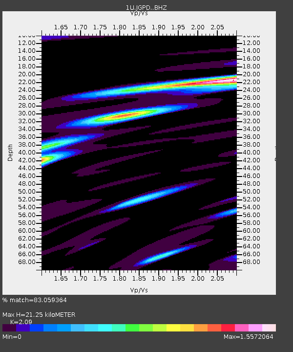
| Estimated Moho Depth: |
21.25 km |
| Estimated Crust Vp/Vs: |
2.09 |
| Assumed Crust Vp: |
6.472 km/s |
| Estimated Crust Vs: |
3.097 km/s |
| Estimated Crust Poisson's Ratio: |
0.35 |
|
| Radial Match: |
83.059364 % |
| Radial Bump: |
400 |
| Transverse Match: |
64.69195 % |
| Transverse Bump: |
400 |
| SOD ConfigId: |
7422571 |
| Insert Time: |
2019-04-17 22:53:02.286 +0000 |
| GWidth: |
2.5 |
| Max Bumps: |
400 |
| Tol: |
0.001 |
|

Signal To Noise
| Channel | StoN | STA | LTA |
| 1U:JGPD: :BHZ:20150328T22:35:58.200Z | 2.294078 | 2.761204E-7 | 1.2036226E-7 |
| 1U:JGPD: :BHN:20150328T22:35:58.200Z | 2.3998742 | 3.4744767E-7 | 1.4477745E-7 |
| 1U:JGPD: :BHE:20150328T22:35:58.200Z | 0.83145094 | 1.6008721E-7 | 1.9253957E-7 |
| Arrivals |
| Ps | 3.8 SECOND |
| PpPs | 9.6 SECOND |
| PsPs/PpSs | 13 SECOND |


