You are here: Home > Network List > AK - Alaska Regional Network Stations List
> Station RKAV Rock Avalanche, AK, USA > Earthquake Result Viewer
RKAV Rock Avalanche, AK, USA - Earthquake Result Viewer
| Earthquake location: |
New Britain Region, P.N.G. |
| Earthquake latitude/longitude: |
-6.2/152.8 |
| Earthquake time(UTC): |
2014/07/04 (185) 15:00:26 GMT |
| Earthquake Depth: |
10 km |
| Earthquake Magnitude: |
6.6 MWP, 6.7 MI |
| Earthquake Catalog/Contributor: |
NEIC PDE/NEIC COMCAT |
|
| Network: |
AK Alaska Regional Network |
| Station: |
RKAV Rock Avalanche, AK, USA |
| Lat/Lon: |
60.30 N/141.35 W |
| Elevation: |
1647 m |
|
| Distance: |
83.7 deg |
| Az: |
27.199 deg |
| Baz: |
245.863 deg |
| Ray Param: |
0.045995973 |
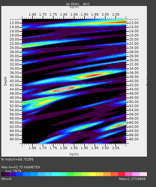
| Estimated Moho Depth: |
43.75 km |
| Estimated Crust Vp/Vs: |
1.80 |
| Assumed Crust Vp: |
6.566 km/s |
| Estimated Crust Vs: |
3.653 km/s |
| Estimated Crust Poisson's Ratio: |
0.28 |
|
| Radial Match: |
86.70295 % |
| Radial Bump: |
400 |
| Transverse Match: |
84.09979 % |
| Transverse Bump: |
400 |
| SOD ConfigId: |
751272 |
| Insert Time: |
2014-07-18 15:10:34.702 +0000 |
| GWidth: |
2.5 |
| Max Bumps: |
400 |
| Tol: |
0.001 |
|

Signal To Noise
| Channel | StoN | STA | LTA |
| AK:RKAV: :BHZ:20140704T15:12:23.908027Z | 38.602203 | 2.5753898E-6 | 6.671613E-8 |
| AK:RKAV: :BHN:20140704T15:12:23.908027Z | 4.8420086 | 4.817772E-7 | 9.9499445E-8 |
| AK:RKAV: :BHE:20140704T15:12:23.908027Z | 10.424714 | 7.713527E-7 | 7.3992695E-8 |
| Arrivals |
| Ps | 5.5 SECOND |
| PpPs | 18 SECOND |
| PsPs/PpSs | 24 SECOND |


