You are here: Home > Network List > CB - China National Seismic Network Stations List
> Station XLT Xilinhaote,Neimeng Province > Earthquake Result Viewer
XLT Xilinhaote,Neimeng Province - Earthquake Result Viewer
| Earthquake location: |
Minahassa Peninsula, Sulawesi |
| Earthquake latitude/longitude: |
0.4/122.0 |
| Earthquake time(UTC): |
2015/03/28 (087) 22:28:51 GMT |
| Earthquake Depth: |
124 km |
| Earthquake Magnitude: |
5.8 MB |
| Earthquake Catalog/Contributor: |
NEIC PDE/NEIC ALERT |
|
| Network: |
CB China National Seismic Network |
| Station: |
XLT Xilinhaote,Neimeng Province |
| Lat/Lon: |
43.90 N/116.08 E |
| Elevation: |
1030 m |
|
| Distance: |
43.6 deg |
| Az: |
353.794 deg |
| Baz: |
171.4 deg |
| Ray Param: |
0.071982846 |
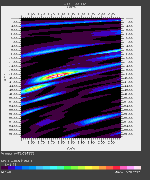
| Estimated Moho Depth: |
38.5 km |
| Estimated Crust Vp/Vs: |
1.78 |
| Assumed Crust Vp: |
6.459 km/s |
| Estimated Crust Vs: |
3.629 km/s |
| Estimated Crust Poisson's Ratio: |
0.27 |
|
| Radial Match: |
95.034355 % |
| Radial Bump: |
269 |
| Transverse Match: |
85.85316 % |
| Transverse Bump: |
400 |
| SOD ConfigId: |
7422571 |
| Insert Time: |
2019-04-17 22:54:11.000 +0000 |
| GWidth: |
2.5 |
| Max Bumps: |
400 |
| Tol: |
0.001 |
|

Signal To Noise
| Channel | StoN | STA | LTA |
| CB:XLT:00:BHZ:20150328T22:36:13.200Z | 3.8109088 | 4.840497E-7 | 1.2701686E-7 |
| CB:XLT:00:BHN:20150328T22:36:13.200Z | 3.8662786 | 2.6452273E-7 | 6.841791E-8 |
| CB:XLT:00:BHE:20150328T22:36:13.200Z | 1.1068127 | 1.05225006E-7 | 9.5070284E-8 |
| Arrivals |
| Ps | 5.0 SECOND |
| PpPs | 16 SECOND |
| PsPs/PpSs | 20 SECOND |


