You are here: Home > Network List > AV - Alaska Volcano Observatory Stations List
> Station AMKA Regional Station, Amchitka Island, Alaska > Earthquake Result Viewer
AMKA Regional Station, Amchitka Island, Alaska - Earthquake Result Viewer
| Earthquake location: |
New Britain Region, P.N.G. |
| Earthquake latitude/longitude: |
-6.2/152.8 |
| Earthquake time(UTC): |
2014/07/04 (185) 15:00:26 GMT |
| Earthquake Depth: |
10 km |
| Earthquake Magnitude: |
6.6 MWP, 6.7 MI |
| Earthquake Catalog/Contributor: |
NEIC PDE/NEIC COMCAT |
|
| Network: |
AV Alaska Volcano Observatory |
| Station: |
AMKA Regional Station, Amchitka Island, Alaska |
| Lat/Lon: |
51.38 N/179.30 E |
| Elevation: |
116 m |
|
| Distance: |
61.7 deg |
| Az: |
18.505 deg |
| Baz: |
210.232 deg |
| Ray Param: |
0.060706303 |
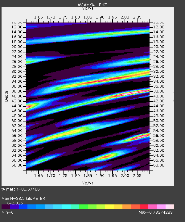
| Estimated Moho Depth: |
38.5 km |
| Estimated Crust Vp/Vs: |
2.03 |
| Assumed Crust Vp: |
6.183 km/s |
| Estimated Crust Vs: |
3.053 km/s |
| Estimated Crust Poisson's Ratio: |
0.34 |
|
| Radial Match: |
81.67466 % |
| Radial Bump: |
400 |
| Transverse Match: |
78.68256 % |
| Transverse Bump: |
398 |
| SOD ConfigId: |
751272 |
| Insert Time: |
2014-07-18 15:15:34.261 +0000 |
| GWidth: |
2.5 |
| Max Bumps: |
400 |
| Tol: |
0.001 |
|
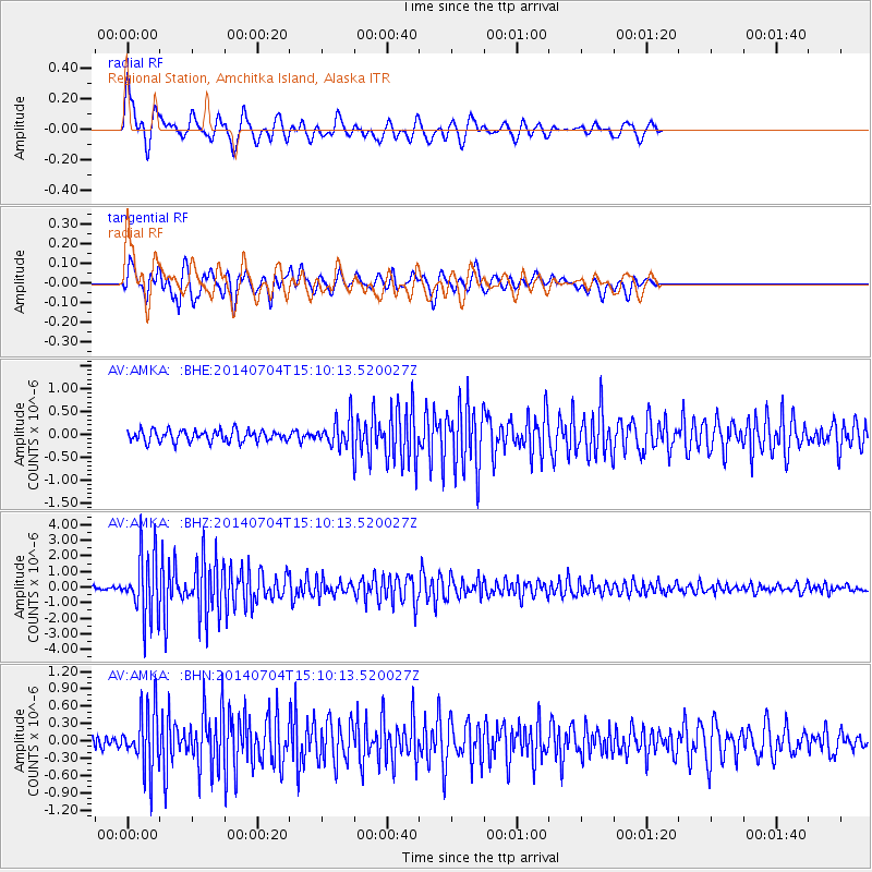
Signal To Noise
| Channel | StoN | STA | LTA |
| AV:AMKA: :BHZ:20140704T15:10:13.520027Z | 15.283965 | 2.056089E-6 | 1.3452589E-7 |
| AV:AMKA: :BHN:20140704T15:10:13.520027Z | 5.4075174 | 5.3013827E-7 | 9.8037276E-8 |
| AV:AMKA: :BHE:20140704T15:10:13.520027Z | 2.4322474 | 3.0434967E-7 | 1.2513105E-7 |
| Arrivals |
| Ps | 6.6 SECOND |
| PpPs | 18 SECOND |
| PsPs/PpSs | 25 SECOND |


