You are here: Home > Network List > IU - Global Seismograph Network (GSN - IRIS/USGS) Stations List
> Station MAKZ Makanchi, Kazakhstan > Earthquake Result Viewer
MAKZ Makanchi, Kazakhstan - Earthquake Result Viewer
| Earthquake location: |
New Britain Region, P.N.G. |
| Earthquake latitude/longitude: |
-6.2/152.8 |
| Earthquake time(UTC): |
2014/07/04 (185) 15:00:26 GMT |
| Earthquake Depth: |
10 km |
| Earthquake Magnitude: |
6.6 MWP, 6.7 MI |
| Earthquake Catalog/Contributor: |
NEIC PDE/NEIC COMCAT |
|
| Network: |
IU Global Seismograph Network (GSN - IRIS/USGS) |
| Station: |
MAKZ Makanchi, Kazakhstan |
| Lat/Lon: |
46.81 N/81.98 E |
| Elevation: |
600 m |
|
| Distance: |
81.6 deg |
| Az: |
319.013 deg |
| Baz: |
108.314 deg |
| Ray Param: |
0.047471948 |
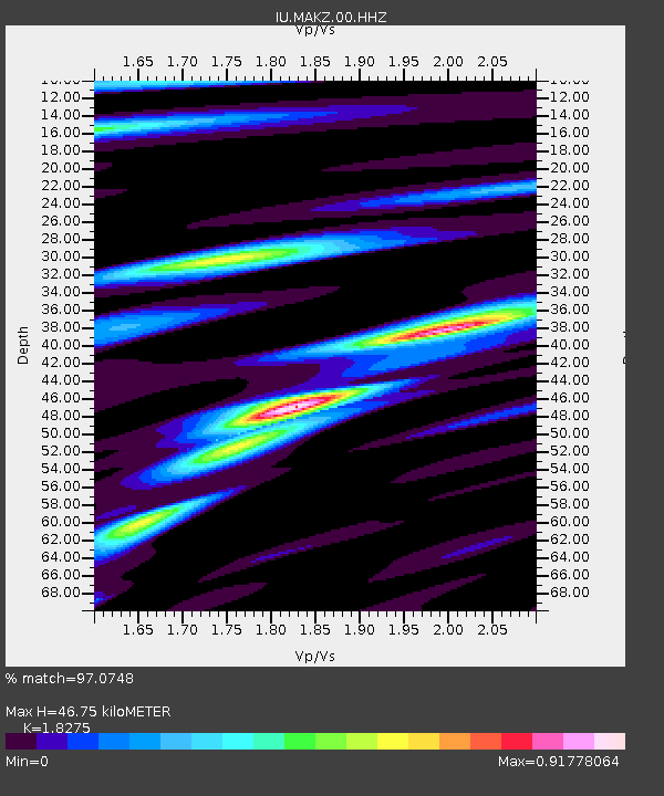
| Estimated Moho Depth: |
46.75 km |
| Estimated Crust Vp/Vs: |
1.83 |
| Assumed Crust Vp: |
6.571 km/s |
| Estimated Crust Vs: |
3.595 km/s |
| Estimated Crust Poisson's Ratio: |
0.29 |
|
| Radial Match: |
97.0748 % |
| Radial Bump: |
329 |
| Transverse Match: |
93.76857 % |
| Transverse Bump: |
400 |
| SOD ConfigId: |
751272 |
| Insert Time: |
2014-07-18 15:26:54.696 +0000 |
| GWidth: |
2.5 |
| Max Bumps: |
400 |
| Tol: |
0.001 |
|

Signal To Noise
| Channel | StoN | STA | LTA |
| IU:MAKZ:00:HHZ:20140704T15:12:12.968025Z | 52.033688 | 1.9828294E-6 | 3.810665E-8 |
| IU:MAKZ:00:HH1:20140704T15:12:12.968025Z | 5.519359 | 1.7576377E-7 | 3.1844962E-8 |
| IU:MAKZ:00:HH2:20140704T15:12:12.968025Z | 18.965473 | 6.220866E-7 | 3.2801005E-8 |
| Arrivals |
| Ps | 6.1 SECOND |
| PpPs | 20 SECOND |
| PsPs/PpSs | 26 SECOND |


