You are here: Home > Network List > JP - Japan Meteorological Agency Seismic Network Stations List
> Station YOJ Yonagunijima Island > Earthquake Result Viewer
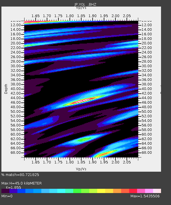
YOJ Yonagunijima Island - Earthquake Result Viewer
| Earthquake location: |
New Britain Region, P.N.G. |
| Earthquake latitude/longitude: |
-6.2/152.8 |
| Earthquake time(UTC): |
2014/07/04 (185) 15:00:26 GMT |
| Earthquake Depth: |
10 km |
| Earthquake Magnitude: |
6.6 MWP, 6.7 MI |
| Earthquake Catalog/Contributor: |
NEIC PDE/NEIC COMCAT |
|
| Network: |
JP Japan Meteorological Agency Seismic Network |
| Station: |
YOJ Yonagunijima Island |
| Lat/Lon: |
24.47 N/123.01 E |
| Elevation: |
32 m |
|
| Distance: |
42.1 deg |
| Az: |
317.502 deg |
| Baz: |
132.516 deg |
| Ray Param: |
0.073364824 |
| Estimated Moho Depth: |
45.0 km |
| Estimated Crust Vp/Vs: |
1.86 |
| Assumed Crust Vp: |
6.183 km/s |
| Estimated Crust Vs: |
3.333 km/s |
| Estimated Crust Poisson's Ratio: |
0.30 |
|
| Radial Match: |
80.721825 % |
| Radial Bump: |
400 |
| Transverse Match: |
70.23711 % |
| Transverse Bump: |
400 |
| SOD ConfigId: |
751272 |
| Insert Time: |
2014-07-18 15:28:30.997 +0000 |
| GWidth: |
2.5 |
| Max Bumps: |
400 |
| Tol: |
0.001 |
|

Signal To Noise
| Channel | StoN | STA | LTA |
| JP:YOJ: :BHZ:20140704T15:07:47.750007Z | 8.2616625 | 1.9896306E-6 | 2.408269E-7 |
| JP:YOJ: :BHN:20140704T15:07:47.750007Z | 2.0552042 | 7.465329E-7 | 3.6324028E-7 |
| JP:YOJ: :BHE:20140704T15:07:47.750007Z | 2.5472913 | 7.627636E-7 | 2.9944104E-7 |
| Arrivals |
| Ps | 6.6 SECOND |
| PpPs | 20 SECOND |
| PsPs/PpSs | 26 SECOND |


