You are here: Home > Network List > S - Seismographs in Schools Projects Stations List
> Station AUKAL John Paul College, Kalgoorlie, WA > Earthquake Result Viewer
AUKAL John Paul College, Kalgoorlie, WA - Earthquake Result Viewer
| Earthquake location: |
New Britain Region, P.N.G. |
| Earthquake latitude/longitude: |
-6.2/152.8 |
| Earthquake time(UTC): |
2014/07/04 (185) 15:00:26 GMT |
| Earthquake Depth: |
10 km |
| Earthquake Magnitude: |
6.6 MWP, 6.7 MI |
| Earthquake Catalog/Contributor: |
NEIC PDE/NEIC COMCAT |
|
| Network: |
S Seismographs in Schools Projects |
| Station: |
AUKAL John Paul College, Kalgoorlie, WA |
| Lat/Lon: |
30.76 S/121.48 E |
| Elevation: |
373 m |
|
| Distance: |
38.2 deg |
| Az: |
226.352 deg |
| Baz: |
56.695 deg |
| Ray Param: |
0.075684406 |
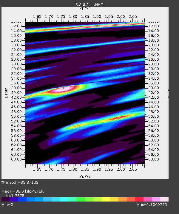
| Estimated Moho Depth: |
38.0 km |
| Estimated Crust Vp/Vs: |
1.76 |
| Assumed Crust Vp: |
6.459 km/s |
| Estimated Crust Vs: |
3.675 km/s |
| Estimated Crust Poisson's Ratio: |
0.26 |
|
| Radial Match: |
85.87132 % |
| Radial Bump: |
317 |
| Transverse Match: |
73.80007 % |
| Transverse Bump: |
400 |
| SOD ConfigId: |
751272 |
| Insert Time: |
2014-07-18 15:33:34.836 +0000 |
| GWidth: |
2.5 |
| Max Bumps: |
400 |
| Tol: |
0.001 |
|

Signal To Noise
| Channel | StoN | STA | LTA |
| S:AUKAL: :HHZ:20140704T15:07:15.570015Z | 3.230044 | 4.7790923E-6 | 1.479575E-6 |
| S:AUKAL: :HHN:20140704T15:07:15.570015Z | 1.645804 | 2.278551E-6 | 1.3844606E-6 |
| S:AUKAL: :HHE:20140704T15:07:15.570015Z | 1.9731766 | 3.603139E-6 | 1.82606E-6 |
| Arrivals |
| Ps | 4.8 SECOND |
| PpPs | 15 SECOND |
| PsPs/PpSs | 20 SECOND |


