You are here: Home > Network List > TA - USArray Transportable Network (new EarthScope stations) Stations List
> Station J05D Fort Rock, OR, USA > Earthquake Result Viewer
J05D Fort Rock, OR, USA - Earthquake Result Viewer
| Earthquake location: |
New Britain Region, P.N.G. |
| Earthquake latitude/longitude: |
-6.2/152.8 |
| Earthquake time(UTC): |
2014/07/04 (185) 15:00:26 GMT |
| Earthquake Depth: |
10 km |
| Earthquake Magnitude: |
6.6 MWP, 6.7 MI |
| Earthquake Catalog/Contributor: |
NEIC PDE/NEIC COMCAT |
|
| Network: |
TA USArray Transportable Network (new EarthScope stations) |
| Station: |
J05D Fort Rock, OR, USA |
| Lat/Lon: |
43.28 N/121.23 W |
| Elevation: |
1541 m |
|
| Distance: |
91.3 deg |
| Az: |
46.769 deg |
| Baz: |
262.734 deg |
| Ray Param: |
0.041614678 |
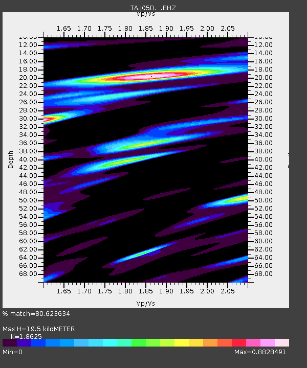
| Estimated Moho Depth: |
19.5 km |
| Estimated Crust Vp/Vs: |
1.86 |
| Assumed Crust Vp: |
6.597 km/s |
| Estimated Crust Vs: |
3.542 km/s |
| Estimated Crust Poisson's Ratio: |
0.30 |
|
| Radial Match: |
80.623634 % |
| Radial Bump: |
400 |
| Transverse Match: |
72.63987 % |
| Transverse Bump: |
400 |
| SOD ConfigId: |
751272 |
| Insert Time: |
2014-07-18 15:35:44.675 +0000 |
| GWidth: |
2.5 |
| Max Bumps: |
400 |
| Tol: |
0.001 |
|
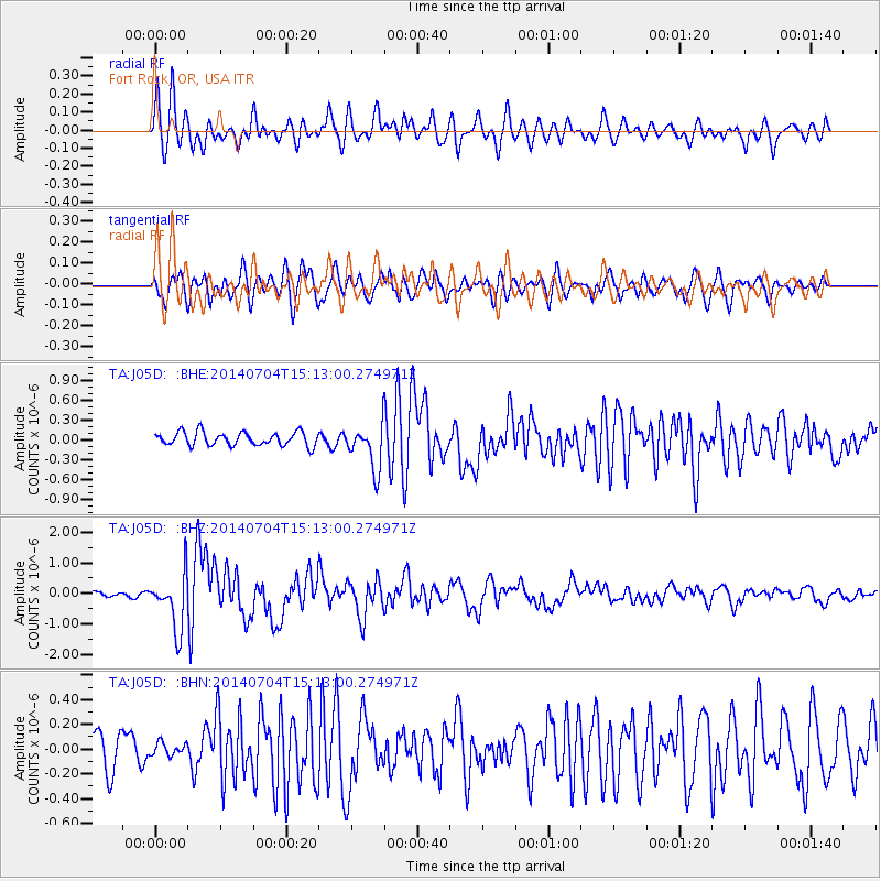
Signal To Noise
| Channel | StoN | STA | LTA |
| TA:J05D: :BHZ:20140704T15:13:00.274971Z | 5.124444 | 9.045665E-7 | 1.7651992E-7 |
| TA:J05D: :BHN:20140704T15:13:00.274971Z | 0.36234176 | 5.231676E-8 | 1.4438513E-7 |
| TA:J05D: :BHE:20140704T15:13:00.274971Z | 3.3071043 | 3.3905636E-7 | 1.0252363E-7 |
| Arrivals |
| Ps | 2.6 SECOND |
| PpPs | 8.3 SECOND |
| PsPs/PpSs | 11 SECOND |


