You are here: Home > Network List > TA - USArray Transportable Network (new EarthScope stations) Stations List
> Station A21K Barrow, AK, USA > Earthquake Result Viewer
A21K Barrow, AK, USA - Earthquake Result Viewer
| Earthquake location: |
New Britain Region, P.N.G. |
| Earthquake latitude/longitude: |
-6.2/152.8 |
| Earthquake time(UTC): |
2014/07/04 (185) 15:00:26 GMT |
| Earthquake Depth: |
10 km |
| Earthquake Magnitude: |
6.6 MWP, 6.7 MI |
| Earthquake Catalog/Contributor: |
NEIC PDE/NEIC COMCAT |
|
| Network: |
TA USArray Transportable Network (new EarthScope stations) |
| Station: |
A21K Barrow, AK, USA |
| Lat/Lon: |
71.32 N/156.62 W |
| Elevation: |
577 m |
|
| Distance: |
84.2 deg |
| Az: |
14.485 deg |
| Baz: |
230.521 deg |
| Ray Param: |
0.045681715 |
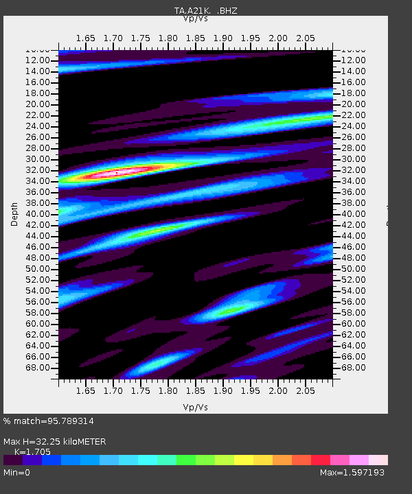
| Estimated Moho Depth: |
32.25 km |
| Estimated Crust Vp/Vs: |
1.71 |
| Assumed Crust Vp: |
6.048 km/s |
| Estimated Crust Vs: |
3.547 km/s |
| Estimated Crust Poisson's Ratio: |
0.24 |
|
| Radial Match: |
95.789314 % |
| Radial Bump: |
400 |
| Transverse Match: |
92.50571 % |
| Transverse Bump: |
400 |
| SOD ConfigId: |
751272 |
| Insert Time: |
2014-07-18 15:36:36.008 +0000 |
| GWidth: |
2.5 |
| Max Bumps: |
400 |
| Tol: |
0.001 |
|
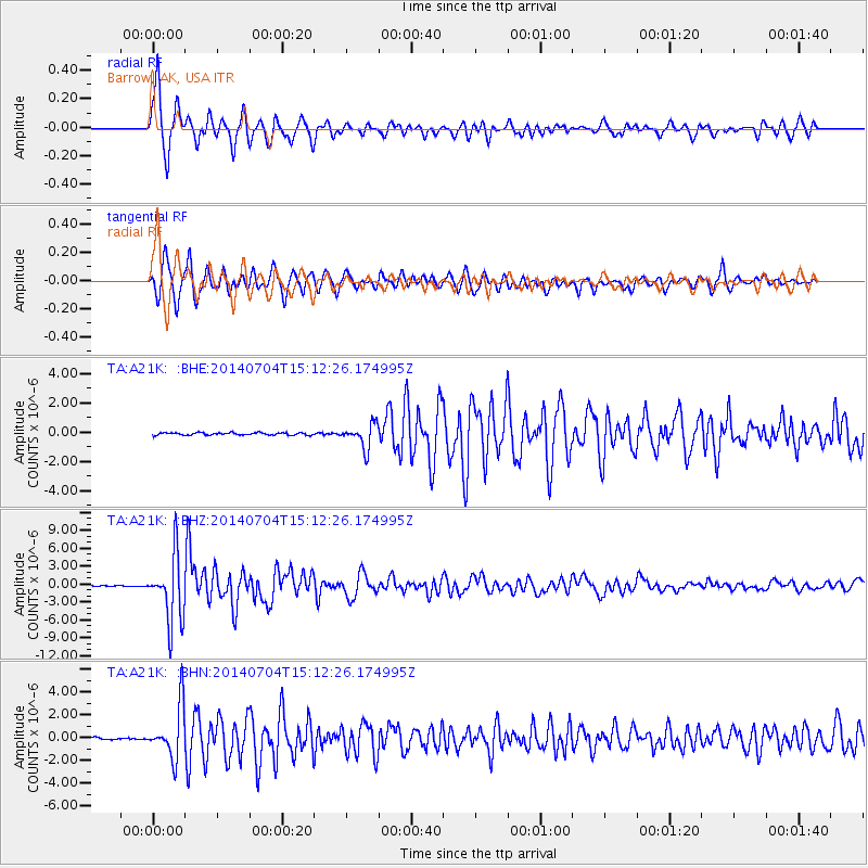
Signal To Noise
| Channel | StoN | STA | LTA |
| TA:A21K: :BHZ:20140704T15:12:26.174995Z | 92.51595 | 5.531088E-6 | 5.9785236E-8 |
| TA:A21K: :BHN:20140704T15:12:26.174995Z | 19.904316 | 2.2856188E-6 | 1.1483032E-7 |
| TA:A21K: :BHE:20140704T15:12:26.174995Z | 9.780384 | 8.218779E-7 | 8.4033296E-8 |
| Arrivals |
| Ps | 3.8 SECOND |
| PpPs | 14 SECOND |
| PsPs/PpSs | 18 SECOND |


