You are here: Home > Network List > UW - Pacific Northwest Regional Seismic Network Stations List
> Station HOOD Mt Hood Meadows, OR CREST BB SMO > Earthquake Result Viewer
HOOD Mt Hood Meadows, OR CREST BB SMO - Earthquake Result Viewer

| Earthquake location: |
New Britain Region, P.N.G. |
| Earthquake latitude/longitude: |
-6.2/152.8 |
| Earthquake time(UTC): |
2014/07/04 (185) 15:00:26 GMT |
| Earthquake Depth: |
10 km |
| Earthquake Magnitude: |
6.6 MWP, 6.7 MI |
| Earthquake Catalog/Contributor: |
NEIC PDE/NEIC COMCAT |
|
| Network: |
UW Pacific Northwest Regional Seismic Network |
| Station: |
HOOD Mt Hood Meadows, OR CREST BB SMO |
| Lat/Lon: |
45.32 N/121.65 W |
| Elevation: |
1520 m |
|
| Distance: |
91.2 deg |
| Az: |
44.71 deg |
| Baz: |
262.487 deg |
| Ray Param: |
0.041617263 |
| Estimated Moho Depth: |
36.0 km |
| Estimated Crust Vp/Vs: |
1.67 |
| Assumed Crust Vp: |
6.597 km/s |
| Estimated Crust Vs: |
3.951 km/s |
| Estimated Crust Poisson's Ratio: |
0.22 |
|
| Radial Match: |
88.4407 % |
| Radial Bump: |
400 |
| Transverse Match: |
85.35233 % |
| Transverse Bump: |
400 |
| SOD ConfigId: |
751272 |
| Insert Time: |
2014-07-18 15:40:17.754 +0000 |
| GWidth: |
2.5 |
| Max Bumps: |
400 |
| Tol: |
0.001 |
|
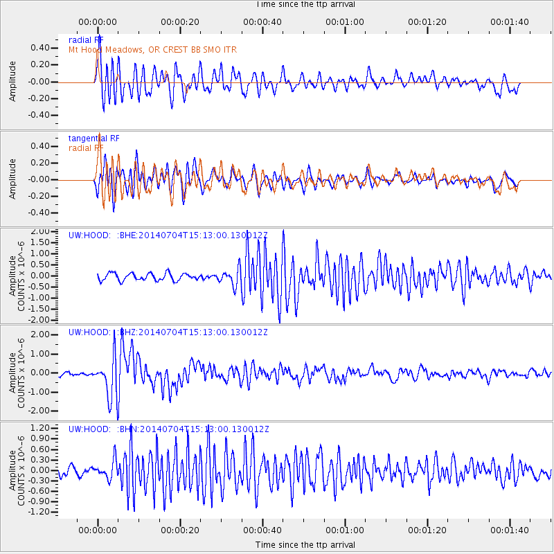
Signal To Noise
| Channel | StoN | STA | LTA |
| UW:HOOD: :BHZ:20140704T15:13:00.130012Z | 11.783782 | 1.1167457E-6 | 9.476972E-8 |
| UW:HOOD: :BHN:20140704T15:13:00.130012Z | 2.385104 | 2.6261247E-7 | 1.10105255E-7 |
| UW:HOOD: :BHE:20140704T15:13:00.130012Z | 2.3003504 | 3.6965278E-7 | 1.6069411E-7 |
| Arrivals |
| Ps | 3.7 SECOND |
| PpPs | 14 SECOND |
| PsPs/PpSs | 18 SECOND |


