You are here: Home > Network List > UW - Pacific Northwest Regional Seismic Network Stations List
> Station LEBA Lebam, WA, USA > Earthquake Result Viewer
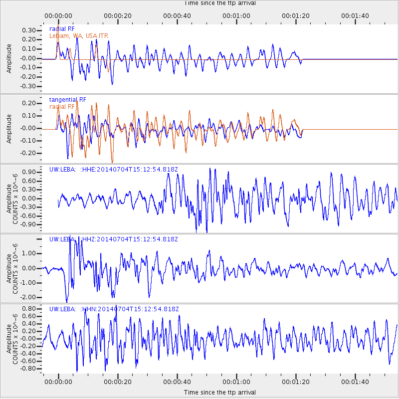
LEBA Lebam, WA, USA - Earthquake Result Viewer
*The percent match for this event was below the threshold and hence no stack was calculated.
| Earthquake location: |
New Britain Region, P.N.G. |
| Earthquake latitude/longitude: |
-6.2/152.8 |
| Earthquake time(UTC): |
2014/07/04 (185) 15:00:26 GMT |
| Earthquake Depth: |
10 km |
| Earthquake Magnitude: |
6.6 MWP, 6.7 MI |
| Earthquake Catalog/Contributor: |
NEIC PDE/NEIC COMCAT |
|
| Network: |
UW Pacific Northwest Regional Seismic Network |
| Station: |
LEBA Lebam, WA, USA |
| Lat/Lon: |
46.55 N/123.56 W |
| Elevation: |
73 m |
|
| Distance: |
90.1 deg |
| Az: |
43.308 deg |
| Baz: |
261.135 deg |
| Ray Param: |
$rayparam |
*The percent match for this event was below the threshold and hence was not used in the summary stack. |
|
| Radial Match: |
80.38285 % |
| Radial Bump: |
400 |
| Transverse Match: |
63.554714 % |
| Transverse Bump: |
400 |
| SOD ConfigId: |
751272 |
| Insert Time: |
2014-07-18 15:40:35.656 +0000 |
| GWidth: |
2.5 |
| Max Bumps: |
400 |
| Tol: |
0.001 |
|
Signal To Noise
| Channel | StoN | STA | LTA |
| UW:LEBA: :HHZ:20140704T15:12:54.818Z | 9.099542 | 1.0517382E-6 | 1.1558144E-7 |
| UW:LEBA: :HHN:20140704T15:12:54.818Z | 1.2866589 | 1.5335597E-7 | 1.191893E-7 |
| UW:LEBA: :HHE:20140704T15:12:54.818Z | 1.7719492 | 2.4823612E-7 | 1.4009213E-7 |
| Arrivals |
| Ps | |
| PpPs | |
| PsPs/PpSs | |


