You are here: Home > Network List > YY13 - Exploring extensional tectonics beyond the Ethiopian Rift Stations List
> Station BAHI High School, Bahir Dar, Ethiopia > Earthquake Result Viewer
BAHI High School, Bahir Dar, Ethiopia - Earthquake Result Viewer
| Earthquake location: |
Minahassa Peninsula, Sulawesi |
| Earthquake latitude/longitude: |
0.4/122.0 |
| Earthquake time(UTC): |
2015/03/28 (087) 22:28:51 GMT |
| Earthquake Depth: |
124 km |
| Earthquake Magnitude: |
5.8 MB |
| Earthquake Catalog/Contributor: |
NEIC PDE/NEIC ALERT |
|
| Network: |
YY Exploring extensional tectonics beyond the Ethiopian Rift |
| Station: |
BAHI High School, Bahir Dar, Ethiopia |
| Lat/Lon: |
11.56 N/37.38 E |
| Elevation: |
1814 m |
|
| Distance: |
84.6 deg |
| Az: |
281.498 deg |
| Baz: |
90.683 deg |
| Ray Param: |
0.045056175 |
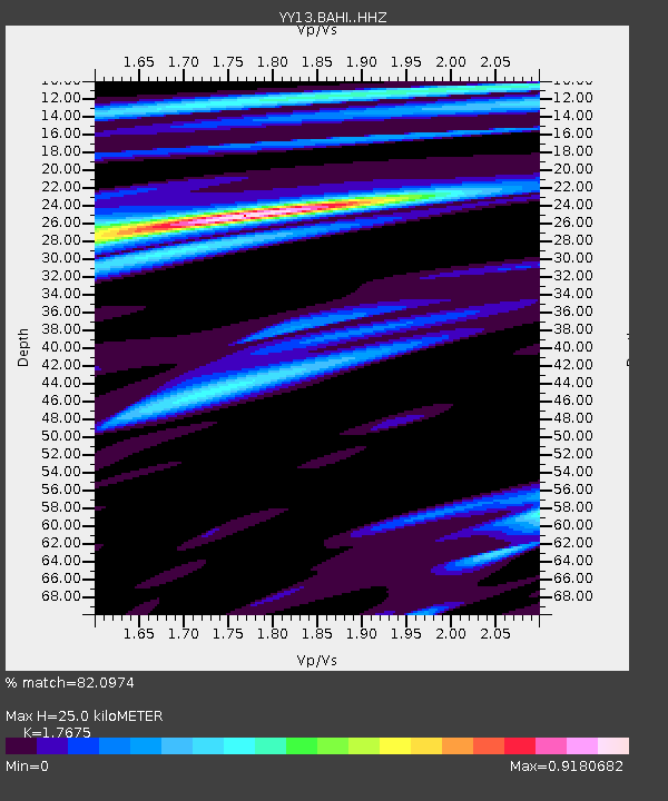
| Estimated Moho Depth: |
25.0 km |
| Estimated Crust Vp/Vs: |
1.77 |
| Assumed Crust Vp: |
6.464 km/s |
| Estimated Crust Vs: |
3.657 km/s |
| Estimated Crust Poisson's Ratio: |
0.26 |
|
| Radial Match: |
82.0974 % |
| Radial Bump: |
400 |
| Transverse Match: |
80.82159 % |
| Transverse Bump: |
400 |
| SOD ConfigId: |
7422571 |
| Insert Time: |
2019-04-17 22:58:03.121 +0000 |
| GWidth: |
2.5 |
| Max Bumps: |
400 |
| Tol: |
0.001 |
|

Signal To Noise
| Channel | StoN | STA | LTA |
| YY:BAHI: :HHZ:20150328T22:40:39.869983Z | 11.092474 | 6.676012E-7 | 6.0185066E-8 |
| YY:BAHI: :HHN:20150328T22:40:39.869983Z | 2.307933 | 9.306048E-8 | 4.0322E-8 |
| YY:BAHI: :HHE:20150328T22:40:39.869983Z | 3.1828885 | 1.45606E-7 | 4.5746496E-8 |
| Arrivals |
| Ps | 3.0 SECOND |
| PpPs | 10 SECOND |
| PsPs/PpSs | 13 SECOND |


