You are here: Home > Network List > CN - Canadian National Seismograph Network Stations List
> Station INK INUVIK, NT > Earthquake Result Viewer
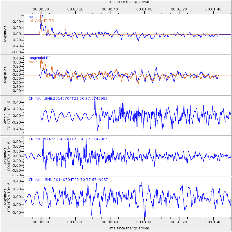
INK INUVIK, NT - Earthquake Result Viewer
*The percent match for this event was below the threshold and hence no stack was calculated.
| Earthquake location: |
Near East Coast Of Honshu, Japan |
| Earthquake latitude/longitude: |
39.7/142.0 |
| Earthquake time(UTC): |
2014/07/04 (185) 22:42:04 GMT |
| Earthquake Depth: |
45 km |
| Earthquake Magnitude: |
5.7 MB |
| Earthquake Catalog/Contributor: |
NEIC PDE/NEIC COMCAT |
|
| Network: |
CN Canadian National Seismograph Network |
| Station: |
INK INUVIK, NT |
| Lat/Lon: |
68.31 N/133.53 W |
| Elevation: |
44 m |
|
| Distance: |
51.8 deg |
| Az: |
28.082 deg |
| Baz: |
282.266 deg |
| Ray Param: |
$rayparam |
*The percent match for this event was below the threshold and hence was not used in the summary stack. |
|
| Radial Match: |
69.52988 % |
| Radial Bump: |
400 |
| Transverse Match: |
55.59785 % |
| Transverse Bump: |
400 |
| SOD ConfigId: |
751272 |
| Insert Time: |
2014-07-18 23:13:56.975 +0000 |
| GWidth: |
2.5 |
| Max Bumps: |
400 |
| Tol: |
0.001 |
|
Signal To Noise
| Channel | StoN | STA | LTA |
| CN:INK: :BHZ:20140704T22:50:37.674998Z | 2.743316 | 3.859273E-7 | 1.4067913E-7 |
| CN:INK: :BHN:20140704T22:50:37.674998Z | 1.3309537 | 1.7050012E-7 | 1.2810371E-7 |
| CN:INK: :BHE:20140704T22:50:37.674998Z | 2.2961612 | 2.2285842E-7 | 9.705696E-8 |
| Arrivals |
| Ps | |
| PpPs | |
| PsPs/PpSs | |


