You are here: Home > Network List > TA - USArray Transportable Network (new EarthScope stations) Stations List
> Station E58A La Victoria, QC, CAN > Earthquake Result Viewer
E58A La Victoria, QC, CAN - Earthquake Result Viewer
| Earthquake location: |
Hokkaido, Japan Region |
| Earthquake latitude/longitude: |
43.0/142.1 |
| Earthquake time(UTC): |
2015/03/29 (088) 02:25:56 GMT |
| Earthquake Depth: |
150 km |
| Earthquake Magnitude: |
4.0 mb, 4.0 mb |
| Earthquake Catalog/Contributor: |
ISC/ISC |
|
| Network: |
TA USArray Transportable Network (new EarthScope stations) |
| Station: |
E58A La Victoria, QC, CAN |
| Lat/Lon: |
46.37 N/73.28 W |
| Elevation: |
233 m |
|
| Distance: |
85.6 deg |
| Az: |
23.708 deg |
| Baz: |
334.801 deg |
| Ray Param: |
0.044311885 |
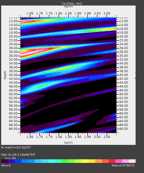
| Estimated Moho Depth: |
28.5 km |
| Estimated Crust Vp/Vs: |
1.64 |
| Assumed Crust Vp: |
6.61 km/s |
| Estimated Crust Vs: |
4.03 km/s |
| Estimated Crust Poisson's Ratio: |
0.20 |
|
| Radial Match: |
84.55257 % |
| Radial Bump: |
400 |
| Transverse Match: |
65.92975 % |
| Transverse Bump: |
270 |
| SOD ConfigId: |
7422571 |
| Insert Time: |
2019-04-17 23:04:10.162 +0000 |
| GWidth: |
2.5 |
| Max Bumps: |
400 |
| Tol: |
0.001 |
|
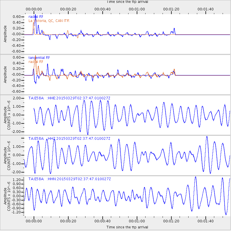
Signal To Noise
| Channel | StoN | STA | LTA |
| TA:E58A: :HHZ:20150329T02:37:47.010027Z | 1.2762214 | 1.2013355E-6 | 9.4132224E-7 |
| TA:E58A: :HHN:20150329T02:37:47.010027Z | 1.2364483 | 4.94057E-7 | 3.9957754E-7 |
| TA:E58A: :HHE:20150329T02:37:47.010027Z | 2.045199 | 1.4627165E-6 | 7.151952E-7 |
| Arrivals |
| Ps | 2.8 SECOND |
| PpPs | 11 SECOND |
| PsPs/PpSs | 14 SECOND |


