You are here: Home > Network List > TA - USArray Transportable Network (new EarthScope stations) Stations List
> Station L44A Lake County Forest Preserve, Grayslake, IL, USA > Earthquake Result Viewer
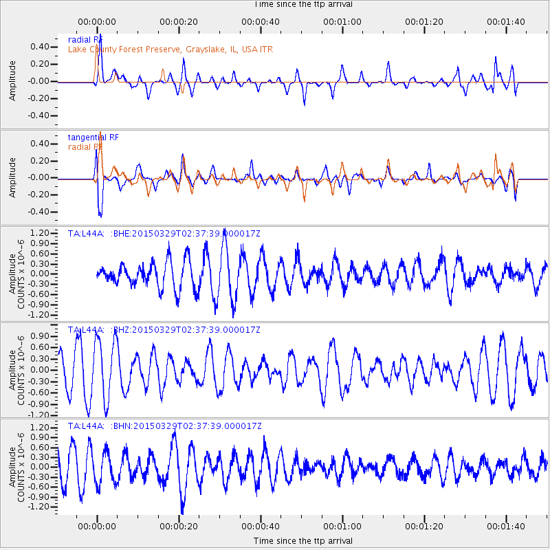
L44A Lake County Forest Preserve, Grayslake, IL, USA - Earthquake Result Viewer
*The percent match for this event was below the threshold and hence no stack was calculated.
| Earthquake location: |
Hokkaido, Japan Region |
| Earthquake latitude/longitude: |
43.0/142.1 |
| Earthquake time(UTC): |
2015/03/29 (088) 02:25:56 GMT |
| Earthquake Depth: |
150 km |
| Earthquake Magnitude: |
4.0 mb, 4.0 mb |
| Earthquake Catalog/Contributor: |
ISC/ISC |
|
| Network: |
TA USArray Transportable Network (new EarthScope stations) |
| Station: |
L44A Lake County Forest Preserve, Grayslake, IL, USA |
| Lat/Lon: |
42.18 N/87.91 W |
| Elevation: |
202 m |
|
| Distance: |
84.0 deg |
| Az: |
34.936 deg |
| Baz: |
325.607 deg |
| Ray Param: |
$rayparam |
*The percent match for this event was below the threshold and hence was not used in the summary stack. |
|
| Radial Match: |
63.03418 % |
| Radial Bump: |
400 |
| Transverse Match: |
72.01389 % |
| Transverse Bump: |
400 |
| SOD ConfigId: |
7422571 |
| Insert Time: |
2019-04-17 23:04:34.248 +0000 |
| GWidth: |
2.5 |
| Max Bumps: |
400 |
| Tol: |
0.001 |
|
Signal To Noise
| Channel | StoN | STA | LTA |
| TA:L44A: :BHZ:20150329T02:37:39.000017Z | 2.2466733 | 8.058728E-7 | 3.58696E-7 |
| TA:L44A: :BHN:20150329T02:37:39.000017Z | 0.87852174 | 4.7309734E-7 | 5.385152E-7 |
| TA:L44A: :BHE:20150329T02:37:39.000017Z | 2.1224687 | 7.925867E-7 | 3.7342684E-7 |
| Arrivals |
| Ps | |
| PpPs | |
| PsPs/PpSs | |


