You are here: Home > Network List > TA - USArray Transportable Network (new EarthScope stations) Stations List
> Station T56A Rocky Mt, VA, USA > Earthquake Result Viewer
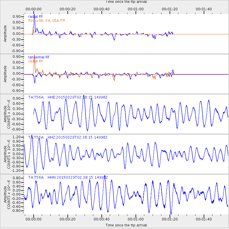
T56A Rocky Mt, VA, USA - Earthquake Result Viewer
*The percent match for this event was below the threshold and hence no stack was calculated.
| Earthquake location: |
Hokkaido, Japan Region |
| Earthquake latitude/longitude: |
43.0/142.1 |
| Earthquake time(UTC): |
2015/03/29 (088) 02:25:56 GMT |
| Earthquake Depth: |
150 km |
| Earthquake Magnitude: |
4.0 mb, 4.0 mb |
| Earthquake Catalog/Contributor: |
ISC/ISC |
|
| Network: |
TA USArray Transportable Network (new EarthScope stations) |
| Station: |
T56A Rocky Mt, VA, USA |
| Lat/Lon: |
37.03 N/80.03 W |
| Elevation: |
387 m |
|
| Distance: |
91.6 deg |
| Az: |
32.484 deg |
| Baz: |
330.525 deg |
| Ray Param: |
$rayparam |
*The percent match for this event was below the threshold and hence was not used in the summary stack. |
|
| Radial Match: |
79.41454 % |
| Radial Bump: |
325 |
| Transverse Match: |
82.63455 % |
| Transverse Bump: |
316 |
| SOD ConfigId: |
7422571 |
| Insert Time: |
2019-04-17 23:04:59.928 +0000 |
| GWidth: |
2.5 |
| Max Bumps: |
400 |
| Tol: |
0.001 |
|
Signal To Noise
| Channel | StoN | STA | LTA |
| TA:T56A: :HHZ:20150329T02:38:15.14998Z | 1.5393889 | 8.784433E-7 | 5.7064415E-7 |
| TA:T56A: :HHN:20150329T02:38:15.14998Z | 1.3163612 | 3.9256787E-7 | 2.98222E-7 |
| TA:T56A: :HHE:20150329T02:38:15.14998Z | 1.6369871 | 7.398223E-7 | 4.5194145E-7 |
| Arrivals |
| Ps | |
| PpPs | |
| PsPs/PpSs | |


