You are here: Home > Network List > TA - USArray Transportable Network (new EarthScope stations) Stations List
> Station G59A Clarenceville, QC, USA > Earthquake Result Viewer
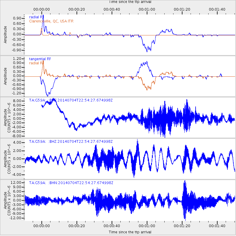
G59A Clarenceville, QC, USA - Earthquake Result Viewer
*The percent match for this event was below the threshold and hence no stack was calculated.
| Earthquake location: |
Near East Coast Of Honshu, Japan |
| Earthquake latitude/longitude: |
39.7/142.0 |
| Earthquake time(UTC): |
2014/07/04 (185) 22:42:04 GMT |
| Earthquake Depth: |
45 km |
| Earthquake Magnitude: |
5.7 MB |
| Earthquake Catalog/Contributor: |
NEIC PDE/NEIC COMCAT |
|
| Network: |
TA USArray Transportable Network (new EarthScope stations) |
| Station: |
G59A Clarenceville, QC, USA |
| Lat/Lon: |
45.08 N/73.18 W |
| Elevation: |
36 m |
|
| Distance: |
89.9 deg |
| Az: |
24.114 deg |
| Baz: |
333.574 deg |
| Ray Param: |
$rayparam |
*The percent match for this event was below the threshold and hence was not used in the summary stack. |
|
| Radial Match: |
22.897125 % |
| Radial Bump: |
400 |
| Transverse Match: |
14.145119 % |
| Transverse Bump: |
400 |
| SOD ConfigId: |
751272 |
| Insert Time: |
2014-07-18 23:37:54.624 +0000 |
| GWidth: |
2.5 |
| Max Bumps: |
400 |
| Tol: |
0.001 |
|
Signal To Noise
| Channel | StoN | STA | LTA |
| TA:G59A: :BHZ:20140704T22:54:27.674998Z | 0.95905316 | 5.954148E-7 | 6.2083603E-7 |
| TA:G59A: :BHN:20140704T22:54:27.674998Z | 1.1529124 | 1.8788968E-6 | 1.629696E-6 |
| TA:G59A: :BHE:20140704T22:54:27.674998Z | 0.61311334 | 2.9371797E-6 | 4.7905983E-6 |
| Arrivals |
| Ps | |
| PpPs | |
| PsPs/PpSs | |


