You are here: Home > Network List > TA - USArray Transportable Network (new EarthScope stations) Stations List
> Station R53A Hurricane, WV, USA > Earthquake Result Viewer
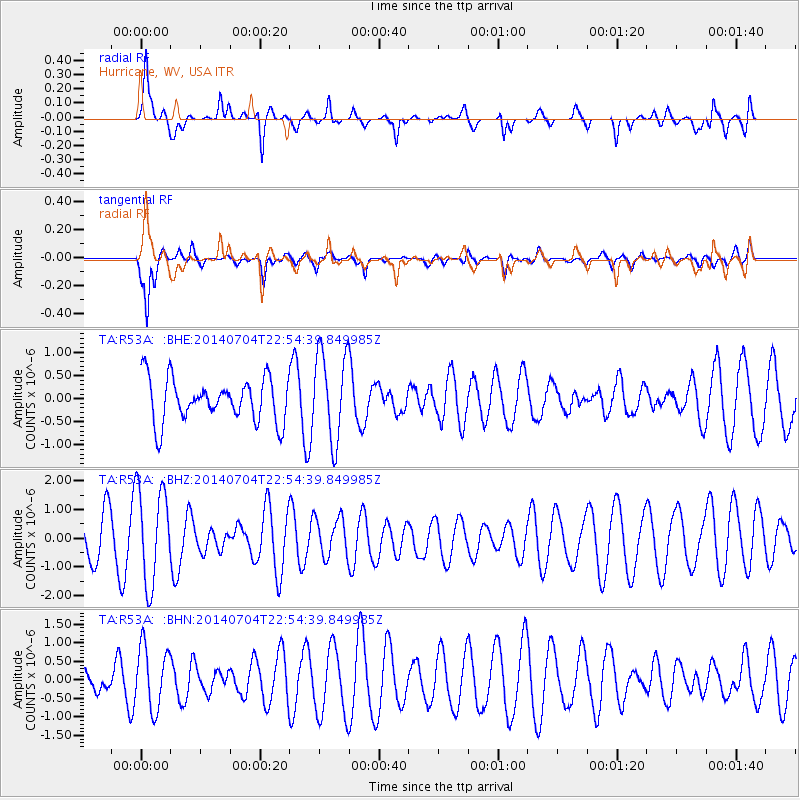
R53A Hurricane, WV, USA - Earthquake Result Viewer
*The percent match for this event was below the threshold and hence no stack was calculated.
| Earthquake location: |
Near East Coast Of Honshu, Japan |
| Earthquake latitude/longitude: |
39.7/142.0 |
| Earthquake time(UTC): |
2014/07/04 (185) 22:42:04 GMT |
| Earthquake Depth: |
45 km |
| Earthquake Magnitude: |
5.7 MB |
| Earthquake Catalog/Contributor: |
NEIC PDE/NEIC COMCAT |
|
| Network: |
TA USArray Transportable Network (new EarthScope stations) |
| Station: |
R53A Hurricane, WV, USA |
| Lat/Lon: |
38.33 N/81.95 W |
| Elevation: |
294 m |
|
| Distance: |
92.5 deg |
| Az: |
33.142 deg |
| Baz: |
327.554 deg |
| Ray Param: |
$rayparam |
*The percent match for this event was below the threshold and hence was not used in the summary stack. |
|
| Radial Match: |
58.04677 % |
| Radial Bump: |
400 |
| Transverse Match: |
73.726845 % |
| Transverse Bump: |
394 |
| SOD ConfigId: |
751272 |
| Insert Time: |
2014-07-18 23:41:10.002 +0000 |
| GWidth: |
2.5 |
| Max Bumps: |
400 |
| Tol: |
0.001 |
|
Signal To Noise
| Channel | StoN | STA | LTA |
| TA:R53A: :BHZ:20140704T22:54:39.849985Z | 2.1925545 | 1.6590798E-6 | 7.566881E-7 |
| TA:R53A: :BHN:20140704T22:54:39.849985Z | 1.9249796 | 8.4963267E-7 | 4.4137232E-7 |
| TA:R53A: :BHE:20140704T22:54:39.849985Z | 2.0672643 | 9.694903E-7 | 4.689726E-7 |
| Arrivals |
| Ps | |
| PpPs | |
| PsPs/PpSs | |


