You are here: Home > Network List > TA - USArray Transportable Network (new EarthScope stations) Stations List
> Station I23K Minto, Yukon-Koyukuk, AK, USA > Earthquake Result Viewer
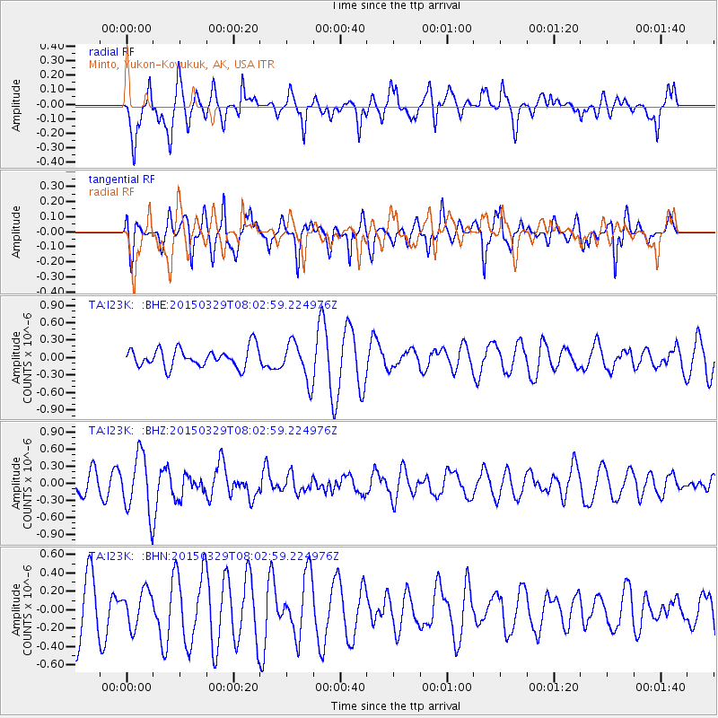
I23K Minto, Yukon-Koyukuk, AK, USA - Earthquake Result Viewer
*The percent match for this event was below the threshold and hence no stack was calculated.
| Earthquake location: |
Northern Molucca Sea |
| Earthquake latitude/longitude: |
1.6/126.4 |
| Earthquake time(UTC): |
2015/03/29 (088) 07:50:53 GMT |
| Earthquake Depth: |
38 km |
| Earthquake Magnitude: |
5.6 MB |
| Earthquake Catalog/Contributor: |
NEIC PDE/NEIC ALERT |
|
| Network: |
TA USArray Transportable Network (new EarthScope stations) |
| Station: |
I23K Minto, Yukon-Koyukuk, AK, USA |
| Lat/Lon: |
65.15 N/149.36 W |
| Elevation: |
149 m |
|
| Distance: |
86.1 deg |
| Az: |
24.925 deg |
| Baz: |
265.419 deg |
| Ray Param: |
$rayparam |
*The percent match for this event was below the threshold and hence was not used in the summary stack. |
|
| Radial Match: |
62.30178 % |
| Radial Bump: |
400 |
| Transverse Match: |
53.962383 % |
| Transverse Bump: |
371 |
| SOD ConfigId: |
7422571 |
| Insert Time: |
2019-04-17 23:09:33.426 +0000 |
| GWidth: |
2.5 |
| Max Bumps: |
400 |
| Tol: |
0.001 |
|
Signal To Noise
| Channel | StoN | STA | LTA |
| TA:I23K: :BHZ:20150329T08:02:59.224976Z | 3.0325916 | 5.284439E-7 | 1.7425488E-7 |
| TA:I23K: :BHN:20150329T08:02:59.224976Z | 0.6100366 | 1.964838E-7 | 3.2208524E-7 |
| TA:I23K: :BHE:20150329T08:02:59.224976Z | 1.9924635 | 3.265346E-7 | 1.6388486E-7 |
| Arrivals |
| Ps | |
| PpPs | |
| PsPs/PpSs | |


