You are here: Home > Network List > TA - USArray Transportable Network (new EarthScope stations) Stations List
> Station A21K Barrow, AK, USA > Earthquake Result Viewer
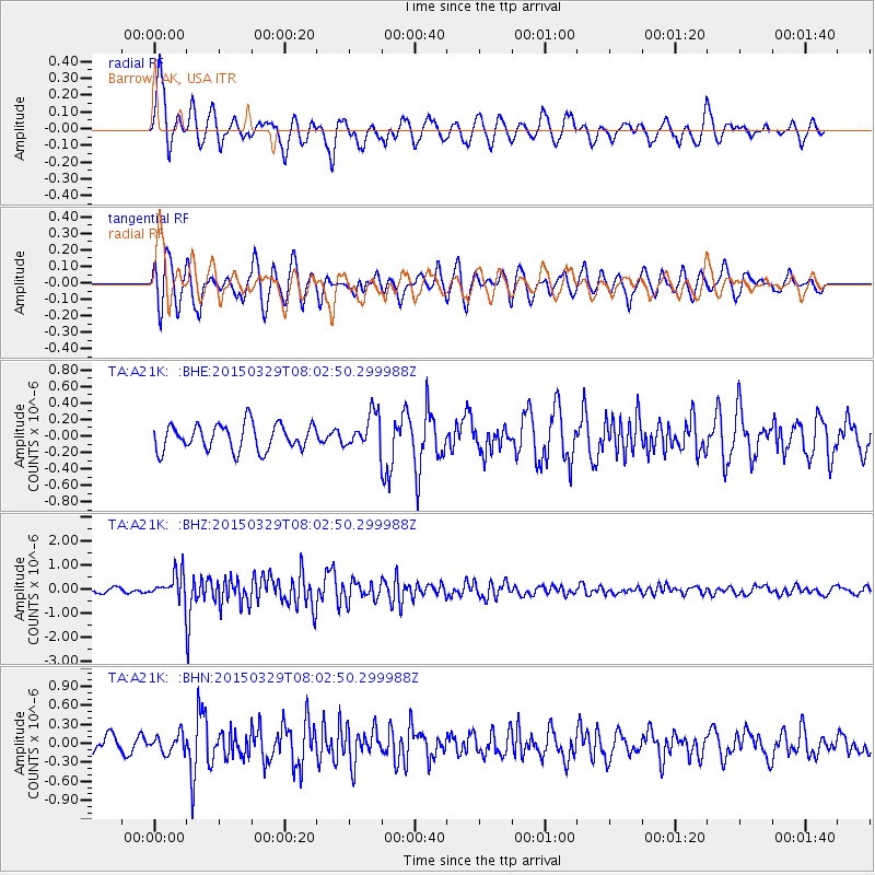
A21K Barrow, AK, USA - Earthquake Result Viewer

| Earthquake location: |
Northern Molucca Sea |
| Earthquake latitude/longitude: |
1.6/126.4 |
| Earthquake time(UTC): |
2015/03/29 (088) 07:50:53 GMT |
| Earthquake Depth: |
38 km |
| Earthquake Magnitude: |
5.6 MB |
| Earthquake Catalog/Contributor: |
NEIC PDE/NEIC ALERT |
|
| Network: |
TA USArray Transportable Network (new EarthScope stations) |
| Station: |
A21K Barrow, AK, USA |
| Lat/Lon: |
71.32 N/156.62 W |
| Elevation: |
577 m |
|
| Distance: |
84.3 deg |
| Az: |
18.386 deg |
| Baz: |
258.123 deg |
| Ray Param: |
0.04554193 |
| Estimated Moho Depth: |
49.5 km |
| Estimated Crust Vp/Vs: |
1.69 |
| Assumed Crust Vp: |
6.048 km/s |
| Estimated Crust Vs: |
3.589 km/s |
| Estimated Crust Poisson's Ratio: |
0.23 |
|
| Radial Match: |
83.96425 % |
| Radial Bump: |
400 |
| Transverse Match: |
65.490005 % |
| Transverse Bump: |
400 |
| SOD ConfigId: |
7422571 |
| Insert Time: |
2019-04-17 23:09:33.326 +0000 |
| GWidth: |
2.5 |
| Max Bumps: |
400 |
| Tol: |
0.001 |
|
Signal To Noise
| Channel | StoN | STA | LTA |
| TA:A21K: :BHZ:20150329T08:02:50.299988Z | 5.3359942 | 5.532249E-7 | 1.03677934E-7 |
| TA:A21K: :BHN:20150329T08:02:50.299988Z | 0.770407 | 1.4443921E-7 | 1.8748429E-7 |
| TA:A21K: :BHE:20150329T08:02:50.299988Z | 1.2886503 | 2.0222258E-7 | 1.5692588E-7 |
| Arrivals |
| Ps | 5.7 SECOND |
| PpPs | 21 SECOND |
| PsPs/PpSs | 27 SECOND |


