You are here: Home > Network List > NI - North-East Italy Broadband Network Stations List
> Station CLUD Cludinico > Earthquake Result Viewer
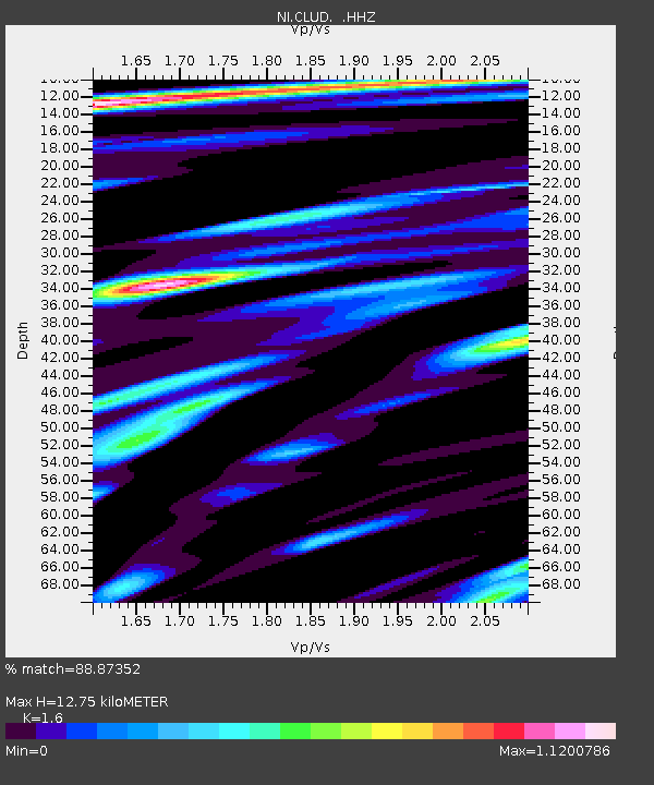
CLUD Cludinico - Earthquake Result Viewer
| Earthquake location: |
Northern Sumatra, Indonesia |
| Earthquake latitude/longitude: |
2.0/97.0 |
| Earthquake time(UTC): |
2014/07/05 (186) 09:39:30 GMT |
| Earthquake Depth: |
30 km |
| Earthquake Magnitude: |
6.0 MWB |
| Earthquake Catalog/Contributor: |
NEIC PDE/NEIC COMCAT |
|
| Network: |
NI North-East Italy Broadband Network |
| Station: |
CLUD Cludinico |
| Lat/Lon: |
46.46 N/12.88 E |
| Elevation: |
635 m |
|
| Distance: |
84.5 deg |
| Az: |
316.301 deg |
| Baz: |
92.874 deg |
| Ray Param: |
0.04539044 |
| Estimated Moho Depth: |
12.75 km |
| Estimated Crust Vp/Vs: |
1.60 |
| Assumed Crust Vp: |
6.35 km/s |
| Estimated Crust Vs: |
3.969 km/s |
| Estimated Crust Poisson's Ratio: |
0.18 |
|
| Radial Match: |
88.87352 % |
| Radial Bump: |
400 |
| Transverse Match: |
76.34217 % |
| Transverse Bump: |
400 |
| SOD ConfigId: |
751272 |
| Insert Time: |
2014-07-19 10:01:38.674 +0000 |
| GWidth: |
2.5 |
| Max Bumps: |
400 |
| Tol: |
0.001 |
|

Signal To Noise
| Channel | StoN | STA | LTA |
| NI:CLUD: :HHZ:20140705T09:51:28.807996Z | 12.450903 | 5.711114E-7 | 4.5869076E-8 |
| NI:CLUD: :HHN:20140705T09:51:28.807996Z | 2.5723817 | 1.3190555E-7 | 5.1277596E-8 |
| NI:CLUD: :HHE:20140705T09:51:28.807996Z | 6.7169166 | 2.7517507E-7 | 4.0967468E-8 |
| Arrivals |
| Ps | 1.2 SECOND |
| PpPs | 5.1 SECOND |
| PsPs/PpSs | 6.3 SECOND |


