You are here: Home > Network List > NI - North-East Italy Broadband Network Stations List
> Station DRE Drenchia > Earthquake Result Viewer
DRE Drenchia - Earthquake Result Viewer
| Earthquake location: |
Northern Sumatra, Indonesia |
| Earthquake latitude/longitude: |
2.0/97.0 |
| Earthquake time(UTC): |
2014/07/05 (186) 09:39:30 GMT |
| Earthquake Depth: |
30 km |
| Earthquake Magnitude: |
6.0 MWB |
| Earthquake Catalog/Contributor: |
NEIC PDE/NEIC COMCAT |
|
| Network: |
NI North-East Italy Broadband Network |
| Station: |
DRE Drenchia |
| Lat/Lon: |
46.17 N/13.65 E |
| Elevation: |
810 m |
|
| Distance: |
84.0 deg |
| Az: |
316.045 deg |
| Baz: |
93.398 deg |
| Ray Param: |
0.045771614 |
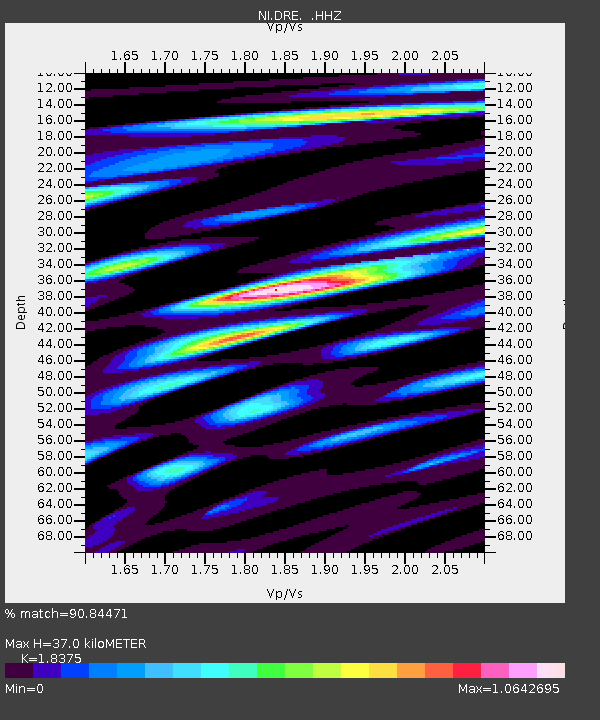
| Estimated Moho Depth: |
37.0 km |
| Estimated Crust Vp/Vs: |
1.84 |
| Assumed Crust Vp: |
6.35 km/s |
| Estimated Crust Vs: |
3.456 km/s |
| Estimated Crust Poisson's Ratio: |
0.29 |
|
| Radial Match: |
90.84471 % |
| Radial Bump: |
400 |
| Transverse Match: |
83.11806 % |
| Transverse Bump: |
400 |
| SOD ConfigId: |
751272 |
| Insert Time: |
2014-07-19 10:01:43.233 +0000 |
| GWidth: |
2.5 |
| Max Bumps: |
400 |
| Tol: |
0.001 |
|

Signal To Noise
| Channel | StoN | STA | LTA |
| NI:DRE: :HHZ:20140705T09:51:26.057996Z | 4.3040204 | 4.887888E-7 | 1.1356564E-7 |
| NI:DRE: :HHN:20140705T09:51:26.057996Z | 1.9912418 | 9.5783484E-8 | 4.8102386E-8 |
| NI:DRE: :HHE:20140705T09:51:26.057996Z | 3.9819887 | 1.4618074E-7 | 3.6710485E-8 |
| Arrivals |
| Ps | 5.0 SECOND |
| PpPs | 16 SECOND |
| PsPs/PpSs | 21 SECOND |


