You are here: Home > Network List > NI - North-East Italy Broadband Network Stations List
> Station SABO Mt. Sabotino > Earthquake Result Viewer
SABO Mt. Sabotino - Earthquake Result Viewer
| Earthquake location: |
Northern Sumatra, Indonesia |
| Earthquake latitude/longitude: |
2.0/97.0 |
| Earthquake time(UTC): |
2014/07/05 (186) 09:39:30 GMT |
| Earthquake Depth: |
30 km |
| Earthquake Magnitude: |
6.0 MWB |
| Earthquake Catalog/Contributor: |
NEIC PDE/NEIC COMCAT |
|
| Network: |
NI North-East Italy Broadband Network |
| Station: |
SABO Mt. Sabotino |
| Lat/Lon: |
45.99 N/13.63 E |
| Elevation: |
621 m |
|
| Distance: |
84.0 deg |
| Az: |
315.858 deg |
| Baz: |
93.371 deg |
| Ray Param: |
0.0457737 |
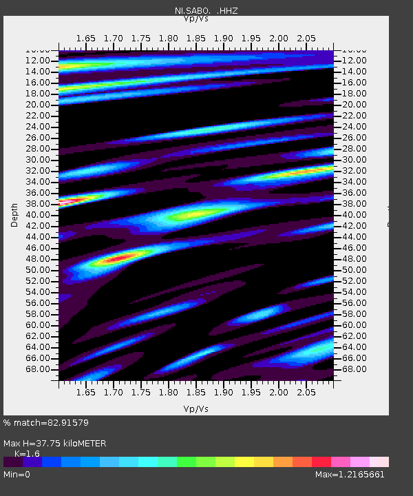
| Estimated Moho Depth: |
37.75 km |
| Estimated Crust Vp/Vs: |
1.60 |
| Assumed Crust Vp: |
6.207 km/s |
| Estimated Crust Vs: |
3.879 km/s |
| Estimated Crust Poisson's Ratio: |
0.18 |
|
| Radial Match: |
82.91579 % |
| Radial Bump: |
400 |
| Transverse Match: |
65.19033 % |
| Transverse Bump: |
400 |
| SOD ConfigId: |
751272 |
| Insert Time: |
2014-07-19 10:01:54.938 +0000 |
| GWidth: |
2.5 |
| Max Bumps: |
400 |
| Tol: |
0.001 |
|

Signal To Noise
| Channel | StoN | STA | LTA |
| NI:SABO: :HHZ:20140705T09:51:26.037976Z | 4.6729054 | 4.7294517E-7 | 1.01210084E-7 |
| NI:SABO: :HHN:20140705T09:51:26.037976Z | 1.3269063 | 1.3918198E-7 | 1.0489209E-7 |
| NI:SABO: :HHE:20140705T09:51:26.037976Z | 1.7207054 | 1.5004134E-7 | 8.719758E-8 |
| Arrivals |
| Ps | 3.7 SECOND |
| PpPs | 15 SECOND |
| PsPs/PpSs | 19 SECOND |


