You are here: Home > Network List > TA - USArray Transportable Network (new EarthScope stations) Stations List
> Station J01E Myrtle Point, OR, USA > Earthquake Result Viewer
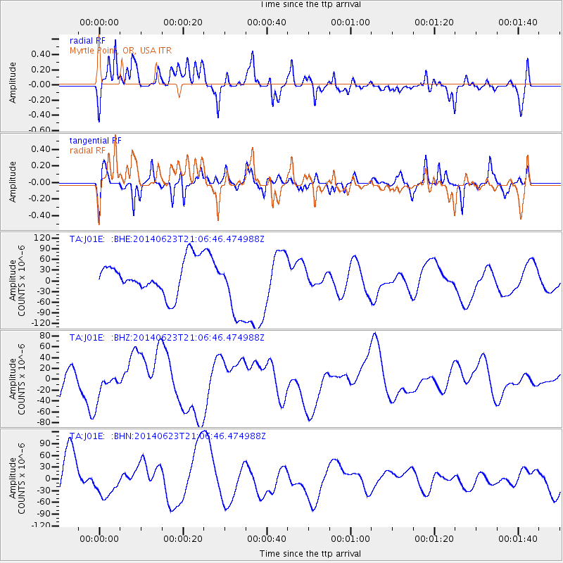
J01E Myrtle Point, OR, USA - Earthquake Result Viewer
*The percent match for this event was below the threshold and hence no stack was calculated.
| Earthquake location: |
Rat Islands, Aleutian Islands |
| Earthquake latitude/longitude: |
51.8/178.5 |
| Earthquake time(UTC): |
2014/06/23 (174) 21:00:01 GMT |
| Earthquake Depth: |
106 km |
| Earthquake Magnitude: |
5.7 MB, 5.2 ML |
| Earthquake Catalog/Contributor: |
NEIC PDE/NEIC COMCAT |
|
| Network: |
TA USArray Transportable Network (new EarthScope stations) |
| Station: |
J01E Myrtle Point, OR, USA |
| Lat/Lon: |
43.16 N/123.93 W |
| Elevation: |
128 m |
|
| Distance: |
38.9 deg |
| Az: |
79.406 deg |
| Baz: |
303.516 deg |
| Ray Param: |
$rayparam |
*The percent match for this event was below the threshold and hence was not used in the summary stack. |
|
| Radial Match: |
55.67938 % |
| Radial Bump: |
400 |
| Transverse Match: |
28.240936 % |
| Transverse Bump: |
325 |
| SOD ConfigId: |
751272 |
| Insert Time: |
2014-07-20 04:53:44.250 +0000 |
| GWidth: |
2.5 |
| Max Bumps: |
400 |
| Tol: |
0.001 |
|
Signal To Noise
| Channel | StoN | STA | LTA |
| TA:J01E: :BHZ:20140623T21:06:46.474988Z | 0.9945243 | 2.3848019E-5 | 2.3979323E-5 |
| TA:J01E: :BHN:20140623T21:06:46.474988Z | 0.51700246 | 3.875908E-5 | 7.4968855E-5 |
| TA:J01E: :BHE:20140623T21:06:46.474988Z | 1.9761738 | 9.092108E-5 | 4.6008645E-5 |
| Arrivals |
| Ps | |
| PpPs | |
| PsPs/PpSs | |


