You are here: Home > Network List > TA - USArray Transportable Network (new EarthScope stations) Stations List
> Station O03E Paynes Creek, CA, USA > Earthquake Result Viewer
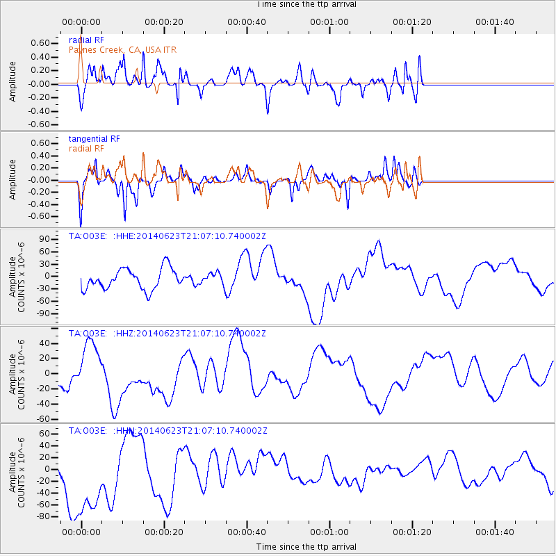
O03E Paynes Creek, CA, USA - Earthquake Result Viewer
*The percent match for this event was below the threshold and hence no stack was calculated.
| Earthquake location: |
Rat Islands, Aleutian Islands |
| Earthquake latitude/longitude: |
51.8/178.5 |
| Earthquake time(UTC): |
2014/06/23 (174) 21:00:01 GMT |
| Earthquake Depth: |
106 km |
| Earthquake Magnitude: |
5.7 MB, 5.2 ML |
| Earthquake Catalog/Contributor: |
NEIC PDE/NEIC COMCAT |
|
| Network: |
TA USArray Transportable Network (new EarthScope stations) |
| Station: |
O03E Paynes Creek, CA, USA |
| Lat/Lon: |
40.29 N/121.80 W |
| Elevation: |
967 m |
|
| Distance: |
41.9 deg |
| Az: |
81.61 deg |
| Baz: |
306.607 deg |
| Ray Param: |
$rayparam |
*The percent match for this event was below the threshold and hence was not used in the summary stack. |
|
| Radial Match: |
61.27097 % |
| Radial Bump: |
400 |
| Transverse Match: |
55.577656 % |
| Transverse Bump: |
269 |
| SOD ConfigId: |
751272 |
| Insert Time: |
2014-07-20 04:55:25.433 +0000 |
| GWidth: |
2.5 |
| Max Bumps: |
400 |
| Tol: |
0.001 |
|
Signal To Noise
| Channel | StoN | STA | LTA |
| TA:O03E: :HHZ:20140623T21:07:10.740002Z | 1.2018807 | 2.8465154E-5 | 2.3683844E-5 |
| TA:O03E: :HHN:20140623T21:07:10.740002Z | 1.5135666 | 7.835222E-5 | 5.1766616E-5 |
| TA:O03E: :HHE:20140623T21:07:10.740002Z | 0.5821273 | 1.4516939E-5 | 2.493774E-5 |
| Arrivals |
| Ps | |
| PpPs | |
| PsPs/PpSs | |


