You are here: Home > Network List > US - United States National Seismic Network Stations List
> Station LAO LASA Array, Montana, USA > Earthquake Result Viewer
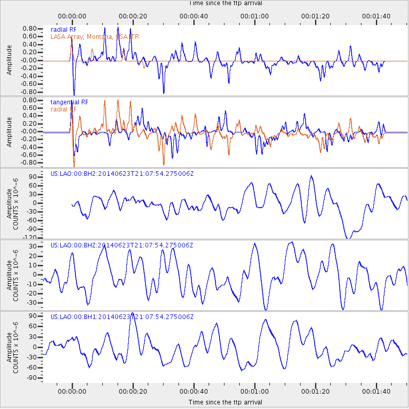
LAO LASA Array, Montana, USA - Earthquake Result Viewer
*The percent match for this event was below the threshold and hence no stack was calculated.
| Earthquake location: |
Rat Islands, Aleutian Islands |
| Earthquake latitude/longitude: |
51.8/178.5 |
| Earthquake time(UTC): |
2014/06/23 (174) 21:00:01 GMT |
| Earthquake Depth: |
106 km |
| Earthquake Magnitude: |
5.7 MB, 5.2 ML |
| Earthquake Catalog/Contributor: |
NEIC PDE/NEIC COMCAT |
|
| Network: |
US United States National Seismic Network |
| Station: |
LAO LASA Array, Montana, USA |
| Lat/Lon: |
46.69 N/106.22 W |
| Elevation: |
902 m |
|
| Distance: |
47.4 deg |
| Az: |
64.81 deg |
| Baz: |
305.331 deg |
| Ray Param: |
$rayparam |
*The percent match for this event was below the threshold and hence was not used in the summary stack. |
|
| Radial Match: |
51.854454 % |
| Radial Bump: |
327 |
| Transverse Match: |
59.238445 % |
| Transverse Bump: |
332 |
| SOD ConfigId: |
751272 |
| Insert Time: |
2014-07-20 04:59:29.187 +0000 |
| GWidth: |
2.5 |
| Max Bumps: |
400 |
| Tol: |
0.001 |
|
Signal To Noise
| Channel | StoN | STA | LTA |
| US:LAO:00:BHZ:20140623T21:07:54.275006Z | 1.732885 | 1.5740274E-5 | 9.083276E-6 |
| US:LAO:00:BH1:20140623T21:07:54.275006Z | 1.985542 | 2.3483224E-5 | 1.182711E-5 |
| US:LAO:00:BH2:20140623T21:07:54.275006Z | 1.5278604 | 3.2933316E-5 | 2.1555186E-5 |
| Arrivals |
| Ps | |
| PpPs | |
| PsPs/PpSs | |


