You are here: Home > Network List > UU - University of Utah Regional Network Stations List
> Station PSUT Pine Spring, UT, USA > Earthquake Result Viewer
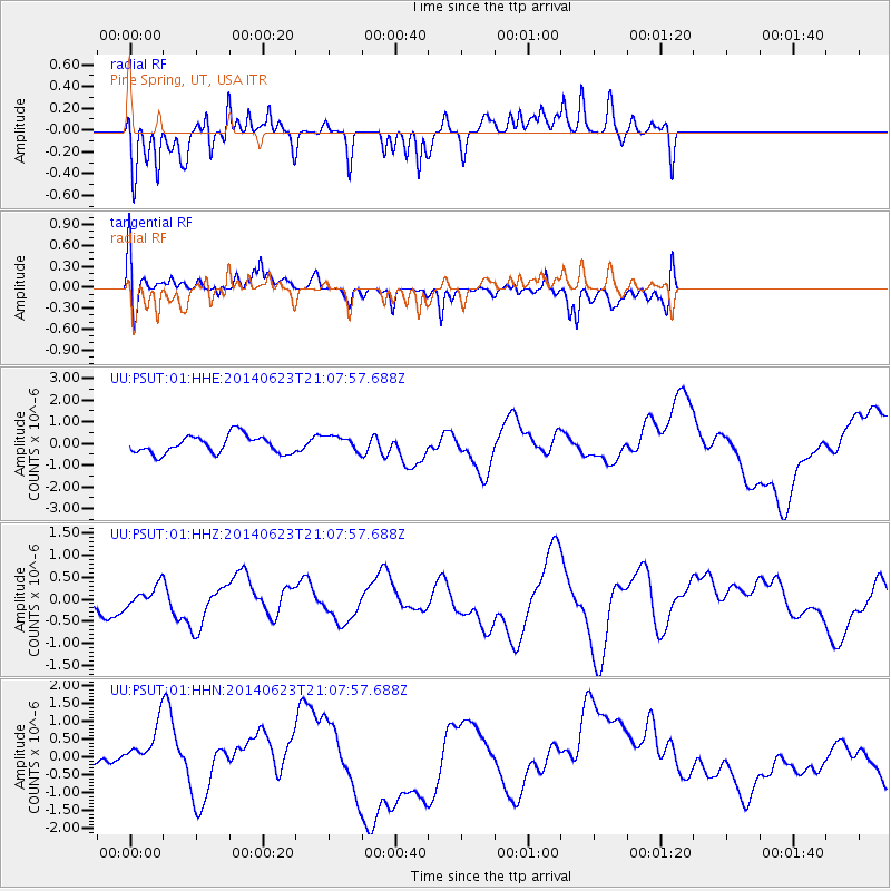
PSUT Pine Spring, UT, USA - Earthquake Result Viewer
*The percent match for this event was below the threshold and hence no stack was calculated.
| Earthquake location: |
Rat Islands, Aleutian Islands |
| Earthquake latitude/longitude: |
51.8/178.5 |
| Earthquake time(UTC): |
2014/06/23 (174) 21:00:01 GMT |
| Earthquake Depth: |
106 km |
| Earthquake Magnitude: |
5.7 MB, 5.2 ML |
| Earthquake Catalog/Contributor: |
NEIC PDE/NEIC COMCAT |
|
| Network: |
UU University of Utah Regional Network |
| Station: |
PSUT Pine Spring, UT, USA |
| Lat/Lon: |
38.53 N/113.85 W |
| Elevation: |
1999 m |
|
| Distance: |
47.8 deg |
| Az: |
78.212 deg |
| Baz: |
309.226 deg |
| Ray Param: |
$rayparam |
*The percent match for this event was below the threshold and hence was not used in the summary stack. |
|
| Radial Match: |
41.503464 % |
| Radial Bump: |
296 |
| Transverse Match: |
38.295727 % |
| Transverse Bump: |
400 |
| SOD ConfigId: |
751272 |
| Insert Time: |
2014-07-20 05:00:36.007 +0000 |
| GWidth: |
2.5 |
| Max Bumps: |
400 |
| Tol: |
0.001 |
|
Signal To Noise
| Channel | StoN | STA | LTA |
| UU:PSUT:01:HHZ:20140623T21:07:57.688Z | 0.7711917 | 2.1567894E-7 | 2.7966968E-7 |
| UU:PSUT:01:HHN:20140623T21:07:57.688Z | 2.9329128 | 6.9695744E-7 | 2.376332E-7 |
| UU:PSUT:01:HHE:20140623T21:07:57.688Z | 0.8801578 | 3.6169055E-7 | 4.1093827E-7 |
| Arrivals |
| Ps | |
| PpPs | |
| PsPs/PpSs | |


