You are here: Home > Network List > AK - Alaska Regional Network Stations List
> Station LOGN Logan Glacier, AK, USA > Earthquake Result Viewer
LOGN Logan Glacier, AK, USA - Earthquake Result Viewer
| Earthquake location: |
New Britain Region, P.N.G. |
| Earthquake latitude/longitude: |
-4.7/152.6 |
| Earthquake time(UTC): |
2015/03/29 (088) 23:48:34 GMT |
| Earthquake Depth: |
66 km |
| Earthquake Magnitude: |
7.7 MWP, 7.6 MI |
| Earthquake Catalog/Contributor: |
NEIC PDE/NEIC COMCAT |
|
| Network: |
AK Alaska Regional Network |
| Station: |
LOGN Logan Glacier, AK, USA |
| Lat/Lon: |
60.82 N/141.00 W |
| Elevation: |
1665 m |
|
| Distance: |
82.9 deg |
| Az: |
26.911 deg |
| Baz: |
247.009 deg |
| Ray Param: |
0.046439584 |
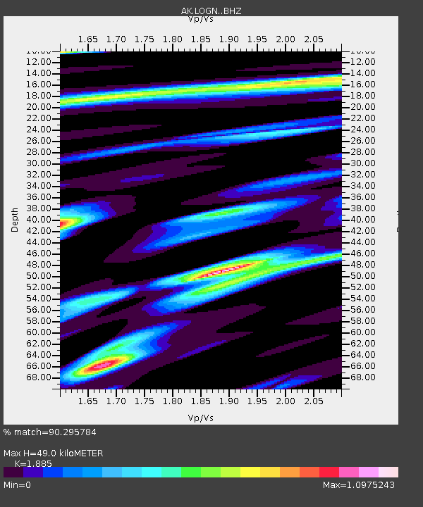
| Estimated Moho Depth: |
49.0 km |
| Estimated Crust Vp/Vs: |
1.88 |
| Assumed Crust Vp: |
6.566 km/s |
| Estimated Crust Vs: |
3.483 km/s |
| Estimated Crust Poisson's Ratio: |
0.30 |
|
| Radial Match: |
90.295784 % |
| Radial Bump: |
400 |
| Transverse Match: |
77.07739 % |
| Transverse Bump: |
400 |
| SOD ConfigId: |
7422571 |
| Insert Time: |
2019-04-17 23:12:01.954 +0000 |
| GWidth: |
2.5 |
| Max Bumps: |
400 |
| Tol: |
0.001 |
|

Signal To Noise
| Channel | StoN | STA | LTA |
| AK:LOGN: :BHZ:20150330T00:00:20.348013Z | 6.5946245 | 1.6658764E-6 | 2.5261127E-7 |
| AK:LOGN: :BHN:20150330T00:00:20.348013Z | 1.3957449 | 4.0705433E-7 | 2.916395E-7 |
| AK:LOGN: :BHE:20150330T00:00:20.348013Z | 2.3064568 | 7.142984E-7 | 3.096951E-7 |
| Arrivals |
| Ps | 6.8 SECOND |
| PpPs | 21 SECOND |
| PsPs/PpSs | 28 SECOND |


