You are here: Home > Network List > AK - Alaska Regional Network Stations List
> Station WRH Wood River Hill > Earthquake Result Viewer
WRH Wood River Hill - Earthquake Result Viewer
| Earthquake location: |
New Britain Region, P.N.G. |
| Earthquake latitude/longitude: |
-4.7/152.6 |
| Earthquake time(UTC): |
2015/03/29 (088) 23:48:34 GMT |
| Earthquake Depth: |
66 km |
| Earthquake Magnitude: |
7.7 MWP, 7.6 MI |
| Earthquake Catalog/Contributor: |
NEIC PDE/NEIC COMCAT |
|
| Network: |
AK Alaska Regional Network |
| Station: |
WRH Wood River Hill |
| Lat/Lon: |
64.47 N/148.09 W |
| Elevation: |
343 m |
|
| Distance: |
81.6 deg |
| Az: |
22.137 deg |
| Baz: |
240.076 deg |
| Ray Param: |
0.0473423 |
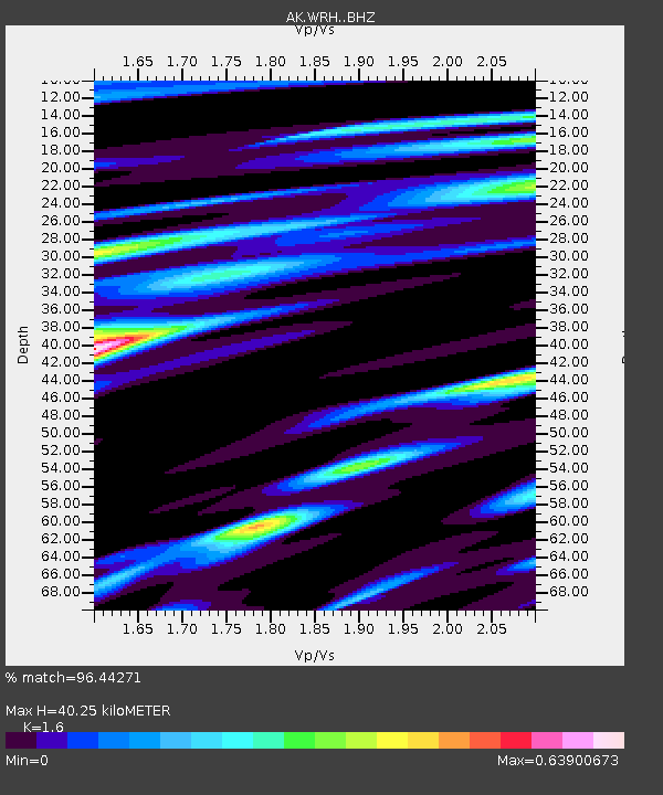
| Estimated Moho Depth: |
40.25 km |
| Estimated Crust Vp/Vs: |
1.60 |
| Assumed Crust Vp: |
6.566 km/s |
| Estimated Crust Vs: |
4.104 km/s |
| Estimated Crust Poisson's Ratio: |
0.18 |
|
| Radial Match: |
96.44271 % |
| Radial Bump: |
400 |
| Transverse Match: |
82.972084 % |
| Transverse Bump: |
400 |
| SOD ConfigId: |
7422571 |
| Insert Time: |
2019-04-17 23:12:34.095 +0000 |
| GWidth: |
2.5 |
| Max Bumps: |
400 |
| Tol: |
0.001 |
|

Signal To Noise
| Channel | StoN | STA | LTA |
| AK:WRH: :BHZ:20150330T00:00:13.588003Z | 8.18105 | 1.9097665E-6 | 2.334378E-7 |
| AK:WRH: :BHN:20150330T00:00:13.588003Z | 2.803302 | 5.065779E-7 | 1.8070757E-7 |
| AK:WRH: :BHE:20150330T00:00:13.588003Z | 2.072808 | 4.5345527E-7 | 2.1876376E-7 |
| Arrivals |
| Ps | 3.8 SECOND |
| PpPs | 15 SECOND |
| PsPs/PpSs | 19 SECOND |


