You are here: Home > Network List > AK - Alaska Regional Network Stations List
> Station ATKA Atka Island Broadband > Earthquake Result Viewer
ATKA Atka Island Broadband - Earthquake Result Viewer
| Earthquake location: |
Near Coast Of Chiapas, Mexico |
| Earthquake latitude/longitude: |
14.7/-92.4 |
| Earthquake time(UTC): |
2014/07/07 (188) 11:23:55 GMT |
| Earthquake Depth: |
60 km |
| Earthquake Magnitude: |
6.9 MWW, 6.9 MWC, 7.1 MI |
| Earthquake Catalog/Contributor: |
NEIC PDE/NEIC COMCAT |
|
| Network: |
AK Alaska Regional Network |
| Station: |
ATKA Atka Island Broadband |
| Lat/Lon: |
52.20 N/174.20 W |
| Elevation: |
55 m |
|
| Distance: |
73.5 deg |
| Az: |
320.553 deg |
| Baz: |
87.209 deg |
| Ray Param: |
0.052852944 |
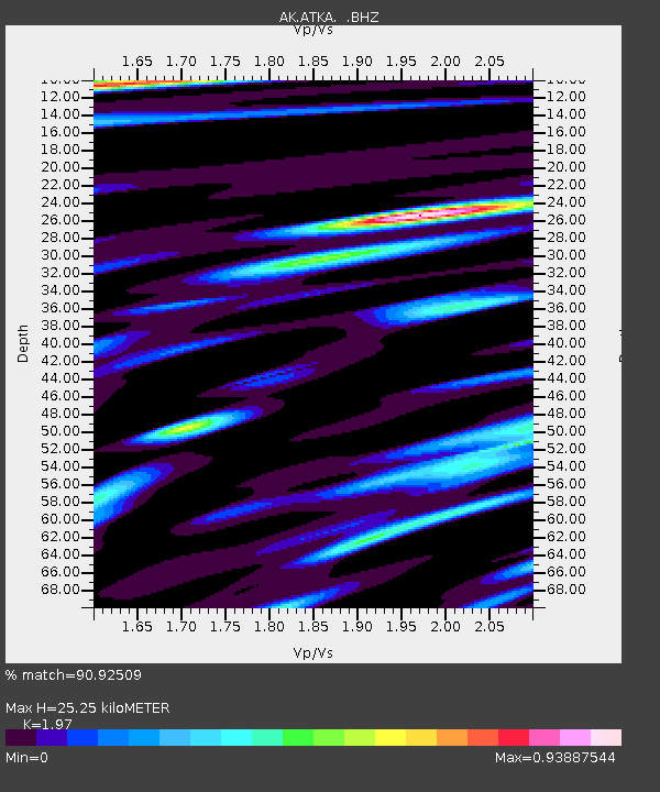
| Estimated Moho Depth: |
25.25 km |
| Estimated Crust Vp/Vs: |
1.97 |
| Assumed Crust Vp: |
5.88 km/s |
| Estimated Crust Vs: |
2.985 km/s |
| Estimated Crust Poisson's Ratio: |
0.33 |
|
| Radial Match: |
90.92509 % |
| Radial Bump: |
400 |
| Transverse Match: |
88.002884 % |
| Transverse Bump: |
400 |
| SOD ConfigId: |
751272 |
| Insert Time: |
2014-07-21 11:38:22.106 +0000 |
| GWidth: |
2.5 |
| Max Bumps: |
400 |
| Tol: |
0.001 |
|

Signal To Noise
| Channel | StoN | STA | LTA |
| AK:ATKA: :BHZ:20140707T11:34:50.648018Z | 30.932817 | 6.478697E-6 | 2.0944412E-7 |
| AK:ATKA: :BHN:20140707T11:34:50.648018Z | 4.158976 | 8.6048885E-7 | 2.068992E-7 |
| AK:ATKA: :BHE:20140707T11:34:50.648018Z | 13.01155 | 2.971165E-6 | 2.2834828E-7 |
| Arrivals |
| Ps | 4.3 SECOND |
| PpPs | 12 SECOND |
| PsPs/PpSs | 17 SECOND |


