You are here: Home > Network List > AU - Australian Seismological Centre Stations List
> Station NWAO Narrogin, Western Australia > Earthquake Result Viewer
NWAO Narrogin, Western Australia - Earthquake Result Viewer
| Earthquake location: |
New Britain Region, P.N.G. |
| Earthquake latitude/longitude: |
-4.7/152.6 |
| Earthquake time(UTC): |
2015/03/29 (088) 23:48:34 GMT |
| Earthquake Depth: |
66 km |
| Earthquake Magnitude: |
7.7 MWP, 7.6 MI |
| Earthquake Catalog/Contributor: |
NEIC PDE/NEIC COMCAT |
|
| Network: |
AU Australian Seismological Centre |
| Station: |
NWAO Narrogin, Western Australia |
| Lat/Lon: |
32.93 S/117.24 E |
| Elevation: |
265 m |
|
| Distance: |
43.3 deg |
| Az: |
225.204 deg |
| Baz: |
57.237 deg |
| Ray Param: |
0.0724684 |
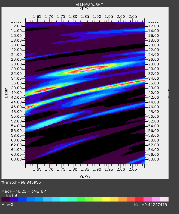
| Estimated Moho Depth: |
46.25 km |
| Estimated Crust Vp/Vs: |
1.60 |
| Assumed Crust Vp: |
6.419 km/s |
| Estimated Crust Vs: |
4.012 km/s |
| Estimated Crust Poisson's Ratio: |
0.18 |
|
| Radial Match: |
98.845955 % |
| Radial Bump: |
126 |
| Transverse Match: |
89.70638 % |
| Transverse Bump: |
400 |
| SOD ConfigId: |
7422571 |
| Insert Time: |
2019-04-17 23:12:44.435 +0000 |
| GWidth: |
2.5 |
| Max Bumps: |
400 |
| Tol: |
0.001 |
|

Signal To Noise
| Channel | StoN | STA | LTA |
| AU:NWAO: :BHZ:20150329T23:55:57.849996Z | 2.2481883 | 3.3953716E-6 | 1.5102702E-6 |
| AU:NWAO: :BHN:20150329T23:55:57.849996Z | 1.4400682 | 1.5889642E-6 | 1.103395E-6 |
| AU:NWAO: :BHE:20150329T23:55:57.849996Z | 2.3559196 | 2.4942997E-6 | 1.0587372E-6 |
| Arrivals |
| Ps | 4.7 SECOND |
| PpPs | 17 SECOND |
| PsPs/PpSs | 22 SECOND |


