You are here: Home > Network List > CC - Cascade Chain Volcano Monitoring Stations List
> Station STD Studebaker Ridge, Mount St Helens, WA > Earthquake Result Viewer
STD Studebaker Ridge, Mount St Helens, WA - Earthquake Result Viewer
| Earthquake location: |
New Britain Region, P.N.G. |
| Earthquake latitude/longitude: |
-4.7/152.6 |
| Earthquake time(UTC): |
2015/03/29 (088) 23:48:34 GMT |
| Earthquake Depth: |
66 km |
| Earthquake Magnitude: |
7.7 MWP, 7.6 MI |
| Earthquake Catalog/Contributor: |
NEIC PDE/NEIC COMCAT |
|
| Network: |
CC Cascade Chain Volcano Monitoring |
| Station: |
STD Studebaker Ridge, Mount St Helens, WA |
| Lat/Lon: |
46.24 N/122.22 W |
| Elevation: |
1268 m |
|
| Distance: |
90.1 deg |
| Az: |
43.763 deg |
| Baz: |
263.288 deg |
| Ray Param: |
0.04168713 |
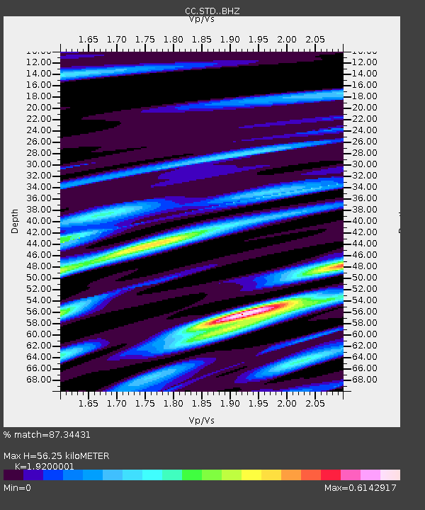
| Estimated Moho Depth: |
56.25 km |
| Estimated Crust Vp/Vs: |
1.92 |
| Assumed Crust Vp: |
6.566 km/s |
| Estimated Crust Vs: |
3.42 km/s |
| Estimated Crust Poisson's Ratio: |
0.31 |
|
| Radial Match: |
87.34431 % |
| Radial Bump: |
400 |
| Transverse Match: |
73.707054 % |
| Transverse Bump: |
400 |
| SOD ConfigId: |
7422571 |
| Insert Time: |
2019-04-17 23:13:34.047 +0000 |
| GWidth: |
2.5 |
| Max Bumps: |
400 |
| Tol: |
0.001 |
|

Signal To Noise
| Channel | StoN | STA | LTA |
| CC:STD: :BHZ:20150330T00:00:55.340017Z | 2.0779772 | 1.0110173E-6 | 4.865392E-7 |
| CC:STD: :BHN:20150330T00:00:55.340017Z | 1.130375 | 2.956819E-7 | 2.6157858E-7 |
| CC:STD: :BHE:20150330T00:00:55.340017Z | 0.84177804 | 2.777141E-7 | 3.299137E-7 |
| Arrivals |
| Ps | 8.0 SECOND |
| PpPs | 25 SECOND |
| PsPs/PpSs | 33 SECOND |


