You are here: Home > Network List > AK - Alaska Regional Network Stations List
> Station SSN Susitna > Earthquake Result Viewer
SSN Susitna - Earthquake Result Viewer
| Earthquake location: |
Near Coast Of Chiapas, Mexico |
| Earthquake latitude/longitude: |
14.7/-92.4 |
| Earthquake time(UTC): |
2014/07/07 (188) 11:23:55 GMT |
| Earthquake Depth: |
60 km |
| Earthquake Magnitude: |
6.9 MWW, 6.9 MWC, 7.1 MI |
| Earthquake Catalog/Contributor: |
NEIC PDE/NEIC COMCAT |
|
| Network: |
AK Alaska Regional Network |
| Station: |
SSN Susitna |
| Lat/Lon: |
61.46 N/150.74 W |
| Elevation: |
1293 m |
|
| Distance: |
62.2 deg |
| Az: |
332.494 deg |
| Baz: |
111.482 deg |
| Ray Param: |
0.06020938 |
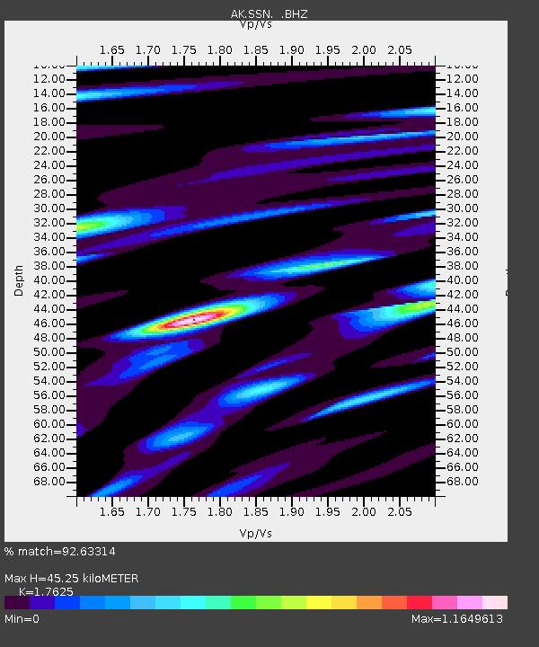
| Estimated Moho Depth: |
45.25 km |
| Estimated Crust Vp/Vs: |
1.76 |
| Assumed Crust Vp: |
6.302 km/s |
| Estimated Crust Vs: |
3.575 km/s |
| Estimated Crust Poisson's Ratio: |
0.26 |
|
| Radial Match: |
92.63314 % |
| Radial Bump: |
400 |
| Transverse Match: |
77.57431 % |
| Transverse Bump: |
400 |
| SOD ConfigId: |
751272 |
| Insert Time: |
2014-07-21 11:42:11.770 +0000 |
| GWidth: |
2.5 |
| Max Bumps: |
400 |
| Tol: |
0.001 |
|

Signal To Noise
| Channel | StoN | STA | LTA |
| AK:SSN: :BHZ:20140707T11:33:40.287971Z | 27.788515 | 2.4798676E-6 | 8.9240736E-8 |
| AK:SSN: :BHN:20140707T11:33:40.287971Z | 3.09186 | 7.309101E-7 | 2.3639818E-7 |
| AK:SSN: :BHE:20140707T11:33:40.287971Z | 5.230937 | 1.0754668E-6 | 2.0559736E-7 |
| Arrivals |
| Ps | 5.7 SECOND |
| PpPs | 19 SECOND |
| PsPs/PpSs | 25 SECOND |


