You are here: Home > Network List > AK - Alaska Regional Network Stations List
> Station WAT6 Susitna Watana 6, AK, USA > Earthquake Result Viewer
WAT6 Susitna Watana 6, AK, USA - Earthquake Result Viewer
| Earthquake location: |
Near Coast Of Chiapas, Mexico |
| Earthquake latitude/longitude: |
14.7/-92.4 |
| Earthquake time(UTC): |
2014/07/07 (188) 11:23:55 GMT |
| Earthquake Depth: |
60 km |
| Earthquake Magnitude: |
6.9 MWW, 6.9 MWC, 7.1 MI |
| Earthquake Catalog/Contributor: |
NEIC PDE/NEIC COMCAT |
|
| Network: |
AK Alaska Regional Network |
| Station: |
WAT6 Susitna Watana 6, AK, USA |
| Lat/Lon: |
62.58 N/147.74 W |
| Elevation: |
1681 m |
|
| Distance: |
61.4 deg |
| Az: |
334.296 deg |
| Baz: |
114.983 deg |
| Ray Param: |
0.060766645 |
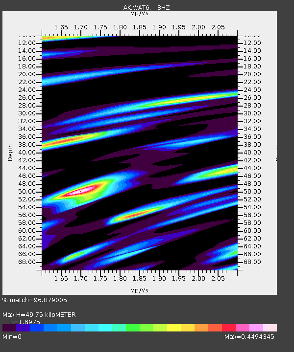
| Estimated Moho Depth: |
49.75 km |
| Estimated Crust Vp/Vs: |
1.70 |
| Assumed Crust Vp: |
6.566 km/s |
| Estimated Crust Vs: |
3.868 km/s |
| Estimated Crust Poisson's Ratio: |
0.23 |
|
| Radial Match: |
96.879005 % |
| Radial Bump: |
320 |
| Transverse Match: |
89.83969 % |
| Transverse Bump: |
400 |
| SOD ConfigId: |
751272 |
| Insert Time: |
2014-07-21 11:42:57.399 +0000 |
| GWidth: |
2.5 |
| Max Bumps: |
400 |
| Tol: |
0.001 |
|

Signal To Noise
| Channel | StoN | STA | LTA |
| AK:WAT6: :BHZ:20140707T11:33:34.508003Z | 18.243765 | 1.9044844E-6 | 1.0439098E-7 |
| AK:WAT6: :BHN:20140707T11:33:34.508003Z | 6.564475 | 4.430759E-7 | 6.749601E-8 |
| AK:WAT6: :BHE:20140707T11:33:34.508003Z | 10.987686 | 8.3169436E-7 | 7.5693315E-8 |
| Arrivals |
| Ps | 5.6 SECOND |
| PpPs | 19 SECOND |
| PsPs/PpSs | 25 SECOND |


