You are here: Home > Network List > AK - Alaska Regional Network Stations List
> Station WRH Wood River Hill > Earthquake Result Viewer
WRH Wood River Hill - Earthquake Result Viewer
| Earthquake location: |
Near Coast Of Chiapas, Mexico |
| Earthquake latitude/longitude: |
14.7/-92.4 |
| Earthquake time(UTC): |
2014/07/07 (188) 11:23:55 GMT |
| Earthquake Depth: |
60 km |
| Earthquake Magnitude: |
6.9 MWW, 6.9 MWC, 7.1 MI |
| Earthquake Catalog/Contributor: |
NEIC PDE/NEIC COMCAT |
|
| Network: |
AK Alaska Regional Network |
| Station: |
WRH Wood River Hill |
| Lat/Lon: |
64.47 N/148.09 W |
| Elevation: |
343 m |
|
| Distance: |
62.3 deg |
| Az: |
336.168 deg |
| Baz: |
115.553 deg |
| Ray Param: |
0.06014853 |
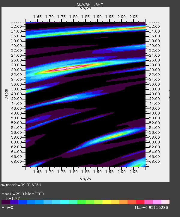
| Estimated Moho Depth: |
29.0 km |
| Estimated Crust Vp/Vs: |
1.77 |
| Assumed Crust Vp: |
6.566 km/s |
| Estimated Crust Vs: |
3.71 km/s |
| Estimated Crust Poisson's Ratio: |
0.27 |
|
| Radial Match: |
89.016266 % |
| Radial Bump: |
388 |
| Transverse Match: |
80.72188 % |
| Transverse Bump: |
400 |
| SOD ConfigId: |
751272 |
| Insert Time: |
2014-07-21 11:43:07.304 +0000 |
| GWidth: |
2.5 |
| Max Bumps: |
400 |
| Tol: |
0.001 |
|

Signal To Noise
| Channel | StoN | STA | LTA |
| AK:WRH: :BHZ:20140707T11:33:40.888008Z | 36.752644 | 2.3293237E-6 | 6.33784E-8 |
| AK:WRH: :BHN:20140707T11:33:40.888008Z | 1.9858943 | 8.453105E-8 | 4.2565738E-8 |
| AK:WRH: :BHE:20140707T11:33:40.888008Z | 10.997312 | 1.0136229E-6 | 9.2170055E-8 |
| Arrivals |
| Ps | 3.6 SECOND |
| PpPs | 12 SECOND |
| PsPs/PpSs | 15 SECOND |


