You are here: Home > Network List > AT - Alaska Tsunami Warning Seismic System Stations List
> Station AKUT Akutan, Alaska > Earthquake Result Viewer
AKUT Akutan, Alaska - Earthquake Result Viewer
| Earthquake location: |
Near Coast Of Chiapas, Mexico |
| Earthquake latitude/longitude: |
14.7/-92.4 |
| Earthquake time(UTC): |
2014/07/07 (188) 11:23:55 GMT |
| Earthquake Depth: |
60 km |
| Earthquake Magnitude: |
6.9 MWW, 6.9 MWC, 7.1 MI |
| Earthquake Catalog/Contributor: |
NEIC PDE/NEIC COMCAT |
|
| Network: |
AT Alaska Tsunami Warning Seismic System |
| Station: |
AKUT Akutan, Alaska |
| Lat/Lon: |
54.14 N/165.77 W |
| Elevation: |
19 m |
|
| Distance: |
68.4 deg |
| Az: |
322.682 deg |
| Baz: |
94.635 deg |
| Ray Param: |
0.056170717 |
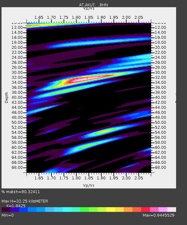
| Estimated Moho Depth: |
32.25 km |
| Estimated Crust Vp/Vs: |
1.84 |
| Assumed Crust Vp: |
5.989 km/s |
| Estimated Crust Vs: |
3.251 km/s |
| Estimated Crust Poisson's Ratio: |
0.29 |
|
| Radial Match: |
90.32411 % |
| Radial Bump: |
400 |
| Transverse Match: |
86.01567 % |
| Transverse Bump: |
400 |
| SOD ConfigId: |
751272 |
| Insert Time: |
2014-07-21 11:43:38.170 +0000 |
| GWidth: |
2.5 |
| Max Bumps: |
400 |
| Tol: |
0.001 |
|

Signal To Noise
| Channel | StoN | STA | LTA |
| AT:AKUT: :BHZ:20140707T11:34:20.219978Z | 23.222675 | 5.383095E-6 | 2.318034E-7 |
| AT:AKUT: :BHN:20140707T11:34:20.219978Z | 1.8943014 | 3.6139957E-7 | 1.9078252E-7 |
| AT:AKUT: :BHE:20140707T11:34:20.219978Z | 18.99482 | 2.3308223E-6 | 1.2270831E-7 |
| Arrivals |
| Ps | 4.7 SECOND |
| PpPs | 15 SECOND |
| PsPs/PpSs | 20 SECOND |


