You are here: Home > Network List > AV - Alaska Volcano Observatory Stations List
> Station AUJA Augustine Cone H, Augustine Volcano, Alaska > Earthquake Result Viewer
AUJA Augustine Cone H, Augustine Volcano, Alaska - Earthquake Result Viewer
| Earthquake location: |
Near Coast Of Chiapas, Mexico |
| Earthquake latitude/longitude: |
14.7/-92.4 |
| Earthquake time(UTC): |
2014/07/07 (188) 11:23:55 GMT |
| Earthquake Depth: |
60 km |
| Earthquake Magnitude: |
6.9 MWW, 6.9 MWC, 7.1 MI |
| Earthquake Catalog/Contributor: |
NEIC PDE/NEIC COMCAT |
|
| Network: |
AV Alaska Volcano Observatory |
| Station: |
AUJA Augustine Cone H, Augustine Volcano, Alaska |
| Lat/Lon: |
59.34 N/153.42 W |
| Elevation: |
376 m |
|
| Distance: |
62.8 deg |
| Az: |
329.727 deg |
| Baz: |
107.879 deg |
| Ray Param: |
0.05986316 |
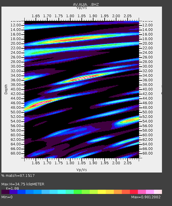
| Estimated Moho Depth: |
34.75 km |
| Estimated Crust Vp/Vs: |
1.86 |
| Assumed Crust Vp: |
5.989 km/s |
| Estimated Crust Vs: |
3.22 km/s |
| Estimated Crust Poisson's Ratio: |
0.30 |
|
| Radial Match: |
87.1517 % |
| Radial Bump: |
400 |
| Transverse Match: |
82.485596 % |
| Transverse Bump: |
400 |
| SOD ConfigId: |
751272 |
| Insert Time: |
2014-07-21 11:44:47.543 +0000 |
| GWidth: |
2.5 |
| Max Bumps: |
400 |
| Tol: |
0.001 |
|
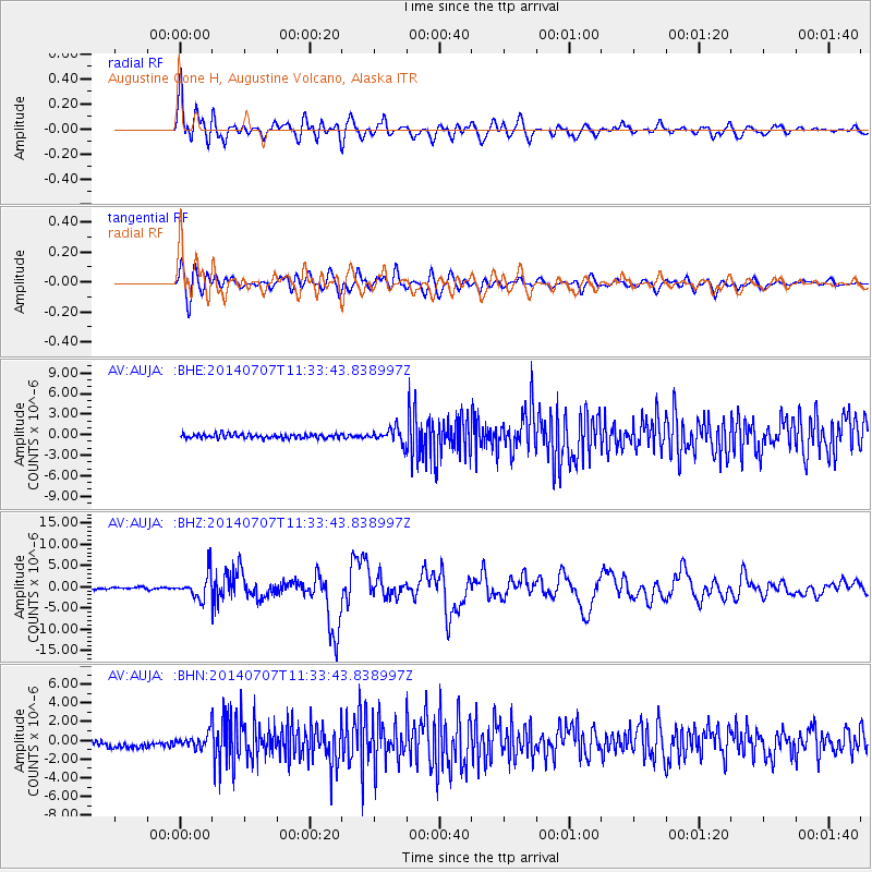
Signal To Noise
| Channel | StoN | STA | LTA |
| AV:AUJA: :BHZ:20140707T11:33:43.838997Z | 12.901613 | 3.0859946E-6 | 2.391945E-7 |
| AV:AUJA: :BHN:20140707T11:33:43.838997Z | 2.2712328 | 9.112149E-7 | 4.0119835E-7 |
| AV:AUJA: :BHE:20140707T11:33:43.838997Z | 3.405228 | 1.080759E-6 | 3.173823E-7 |
| Arrivals |
| Ps | 5.2 SECOND |
| PpPs | 16 SECOND |
| PsPs/PpSs | 21 SECOND |


