You are here: Home > Network List > AV - Alaska Volcano Observatory Stations List
> Station MAPS Pakushin Southeast, Makushin Volcano, Alaska > Earthquake Result Viewer
MAPS Pakushin Southeast, Makushin Volcano, Alaska - Earthquake Result Viewer
| Earthquake location: |
Near Coast Of Chiapas, Mexico |
| Earthquake latitude/longitude: |
14.7/-92.4 |
| Earthquake time(UTC): |
2014/07/07 (188) 11:23:55 GMT |
| Earthquake Depth: |
60 km |
| Earthquake Magnitude: |
6.9 MWW, 6.9 MWC, 7.1 MI |
| Earthquake Catalog/Contributor: |
NEIC PDE/NEIC COMCAT |
|
| Network: |
AV Alaska Volcano Observatory |
| Station: |
MAPS Pakushin Southeast, Makushin Volcano, Alaska |
| Lat/Lon: |
53.81 N/166.94 W |
| Elevation: |
333 m |
|
| Distance: |
69.1 deg |
| Az: |
322.279 deg |
| Baz: |
93.546 deg |
| Ray Param: |
0.055735696 |
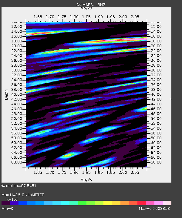
| Estimated Moho Depth: |
15.0 km |
| Estimated Crust Vp/Vs: |
1.60 |
| Assumed Crust Vp: |
3.943 km/s |
| Estimated Crust Vs: |
2.465 km/s |
| Estimated Crust Poisson's Ratio: |
0.18 |
|
| Radial Match: |
87.5451 % |
| Radial Bump: |
400 |
| Transverse Match: |
81.455284 % |
| Transverse Bump: |
400 |
| SOD ConfigId: |
751272 |
| Insert Time: |
2014-07-21 11:44:57.535 +0000 |
| GWidth: |
2.5 |
| Max Bumps: |
400 |
| Tol: |
0.001 |
|

Signal To Noise
| Channel | StoN | STA | LTA |
| AV:MAPS: :BHZ:20140707T11:34:24.359993Z | 42.558033 | 3.3090316E-6 | 7.77534E-8 |
| AV:MAPS: :BHN:20140707T11:34:24.359993Z | 2.291811 | 2.7330574E-7 | 1.1925319E-7 |
| AV:MAPS: :BHE:20140707T11:34:24.359993Z | 6.955521 | 1.0780057E-6 | 1.5498561E-7 |
| Arrivals |
| Ps | 2.3 SECOND |
| PpPs | 9.7 SECOND |
| PsPs/PpSs | 12 SECOND |


