You are here: Home > Network List > JP - Japan Meteorological Agency Seismic Network Stations List
> Station JNU Oita Nakatsue > Earthquake Result Viewer
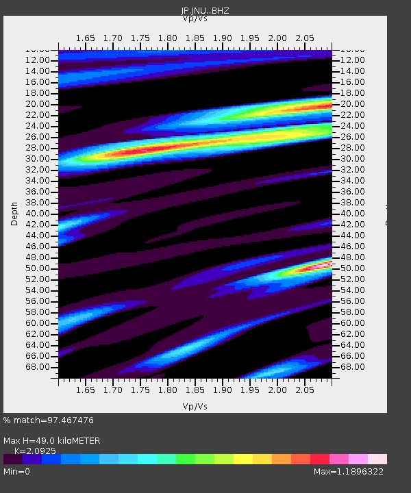
JNU Oita Nakatsue - Earthquake Result Viewer
| Earthquake location: |
New Britain Region, P.N.G. |
| Earthquake latitude/longitude: |
-4.7/152.6 |
| Earthquake time(UTC): |
2015/03/29 (088) 23:48:34 GMT |
| Earthquake Depth: |
66 km |
| Earthquake Magnitude: |
7.7 MWP, 7.6 MI |
| Earthquake Catalog/Contributor: |
NEIC PDE/NEIC COMCAT |
|
| Network: |
JP Japan Meteorological Agency Seismic Network |
| Station: |
JNU Oita Nakatsue |
| Lat/Lon: |
33.12 N/130.88 E |
| Elevation: |
540 m |
|
| Distance: |
42.9 deg |
| Az: |
332.91 deg |
| Baz: |
147.259 deg |
| Ray Param: |
0.07268827 |
| Estimated Moho Depth: |
49.0 km |
| Estimated Crust Vp/Vs: |
2.09 |
| Assumed Crust Vp: |
6.468 km/s |
| Estimated Crust Vs: |
3.091 km/s |
| Estimated Crust Poisson's Ratio: |
0.35 |
|
| Radial Match: |
97.467476 % |
| Radial Bump: |
384 |
| Transverse Match: |
87.99686 % |
| Transverse Bump: |
400 |
| SOD ConfigId: |
7422571 |
| Insert Time: |
2019-04-17 23:15:07.440 +0000 |
| GWidth: |
2.5 |
| Max Bumps: |
400 |
| Tol: |
0.001 |
|

Signal To Noise
| Channel | StoN | STA | LTA |
| JP:JNU: :BHZ:20150329T23:55:55.450002Z | 5.0272646 | 2.1883961E-6 | 4.3530554E-7 |
| JP:JNU: :BHN:20150329T23:55:55.450002Z | 1.6868815 | 8.9209885E-7 | 5.28845E-7 |
| JP:JNU: :BHE:20150329T23:55:55.450002Z | 1.9568896 | 6.843516E-7 | 3.4971396E-7 |
| Arrivals |
| Ps | 8.8 SECOND |
| PpPs | 22 SECOND |
| PsPs/PpSs | 31 SECOND |


