You are here: Home > Network List > KR - Kyrgyz Digital Network Stations List
> Station KDJ Kadji-Say, Kyrgyzstan > Earthquake Result Viewer
KDJ Kadji-Say, Kyrgyzstan - Earthquake Result Viewer
| Earthquake location: |
New Britain Region, P.N.G. |
| Earthquake latitude/longitude: |
-4.7/152.6 |
| Earthquake time(UTC): |
2015/03/29 (088) 23:48:34 GMT |
| Earthquake Depth: |
66 km |
| Earthquake Magnitude: |
7.7 MWP, 7.6 MI |
| Earthquake Catalog/Contributor: |
NEIC PDE/NEIC COMCAT |
|
| Network: |
KR Kyrgyz Digital Network |
| Station: |
KDJ Kadji-Say, Kyrgyzstan |
| Lat/Lon: |
42.12 N/77.18 E |
| Elevation: |
1830 m |
|
| Distance: |
82.4 deg |
| Az: |
313.426 deg |
| Baz: |
103.371 deg |
| Ray Param: |
0.04678581 |
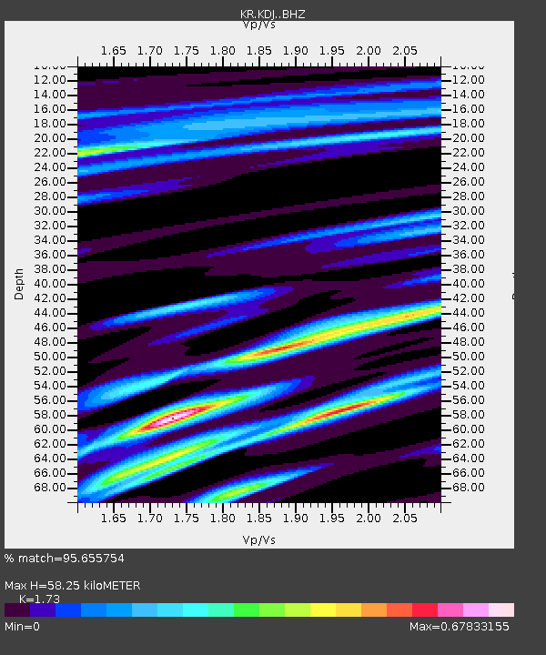
| Estimated Moho Depth: |
58.25 km |
| Estimated Crust Vp/Vs: |
1.73 |
| Assumed Crust Vp: |
6.306 km/s |
| Estimated Crust Vs: |
3.645 km/s |
| Estimated Crust Poisson's Ratio: |
0.25 |
|
| Radial Match: |
95.655754 % |
| Radial Bump: |
400 |
| Transverse Match: |
88.01563 % |
| Transverse Bump: |
400 |
| SOD ConfigId: |
7422571 |
| Insert Time: |
2019-04-17 23:15:20.898 +0000 |
| GWidth: |
2.5 |
| Max Bumps: |
400 |
| Tol: |
0.001 |
|

Signal To Noise
| Channel | StoN | STA | LTA |
| KR:KDJ: :BHZ:20150330T00:00:17.799978Z | 6.2759666 | 6.4536476E-7 | 1.0283114E-7 |
| KR:KDJ: :BHN:20150330T00:00:17.799978Z | 0.5058958 | 8.9664226E-8 | 1.7723852E-7 |
| KR:KDJ: :BHE:20150330T00:00:17.799978Z | 2.3083947 | 2.7131625E-7 | 1.175346E-7 |
| Arrivals |
| Ps | 6.9 SECOND |
| PpPs | 25 SECOND |
| PsPs/PpSs | 31 SECOND |


